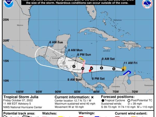
Tropical storm Julia advanced this Saturday over the Caribbean Sea, heading for the Colombian islands of San Andrés, Providencia and Santa Catalina, with winds increasing “steadily and rapidly” until reaching the hurricane category this Saturday.
(President orders hotels in San Andrés to open space for shelters).
The trajectory forecast of the US National Hurricane Center (NHC) indicates that the center of Julia will pass near or over the Colombian archipelago tonight and on Sunday morning it will reach the coast of Nicaragua. Julia or its remnants will then turn west-northwestward and be near the Pacific coast of Central America on Monday.
The NHC warned of the risk of flash flooding and mudslides from the rains of Julia, which at 12:00 GMT this Saturday was located about 165 miles (270 km) east-southeast of the island of Providencia, which in 2020 was hit hard by Hurricane Iota.
(Flights to San Andrés are suspended after a hurricane alert).
San Andrés, Providencia and Santa Catalina, in Colombia, and the Nicaraguan Caribbean coast, from Bluefields to Puerto Cabezas, are under a hurricane alert. There are also less serious warnings for other areas of Nicaragua and Honduras. Interests elsewhere along the Pacific coasts of Nicaragua, Honduras, and El Salvador should monitor Julia’s progress, according to the NHC.
Julia is moving toward the west near 21 mph (33 km/h) and will maintain that heading through tonight, followed by a westward or west-northwestward motion at a slower forward speed on Sunday. and on Sunday night.
(Colombia, with the cheapest cities to live in South America).
Maximum sustained winds are near 60 mph (95 km/h) with higher gusts Steady and rapid strengthening is forecast as Julia crosses the southwestern Caribbean and is forecast to become a hurricane later today and that it weakens once it has entered inland in Nicaragua.
It is likely to become a remnant low on Monday. Tropical-storm-force winds extend outward up to 115 miles (185 km) from the center.
EFE


