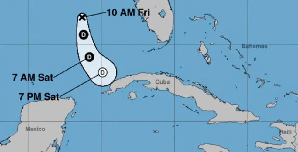
The tropical depression “Two” that formed in the Atlantic basin gained strength this Friday and became Tropical Storm Arlene, the first named system of the current hurricane season slowly moving through the Gulf of Mexico.
The most recent report from the Forecast Center of the Cuban Institute of Meteorology (Insmet) indicates that the storm has maximum sustained winds of 65 kilometers per hour.
Arlene is moving near due south at the rate of 7 kilometers per hour. Its central region was estimated to be about 425 kilometers west of Fort Myers, on the west coast of Florida, and 550 kilometers north-northwest of Cape San Antonio, western end of Pinar del Río.
Tropical Depression Two has been upgraded to Tropical Storm #Arlene in the Gulf of Mexico. No change to the forecast and no significant threat to land. See https://t.co/tW4KeGe9uJ for details. pic.twitter.com/VCKrb9BHwp
—National Hurricane Center (@NHC_Atlantic) June 2, 2023
The Insmet adds that the organism will continue to move towards the south in the next 12 to 24 hours, slightly increasing its travel speed. However, it will gradually weaken from tonight to become a remnant low during Saturday in the southeastern waters of the Gulf of Mexico, north of the western region of Cuba.
The Cuban meteorologist Elier Pila called the trajectory of this phenomenon “rare”, which is “within a current in a cyclonic direction (counterclockwise) in the low and middle levels of the atmosphere, which makes it” go moving little by little towards the south, in this unusual trajectory”.
Arlene is a weak system right now and no alerts have been issued for either Cuba or Florida. The Insmet estimates a short life and predicts that it could collapse before reaching the mainland.
The hurricane season officially began in the Atlantic on Thursday, June 1, and will run until November 30.
Last year’s season had 14 named storms, with extensive damage from Hurricanes Ian, Nicole and Fiona.


