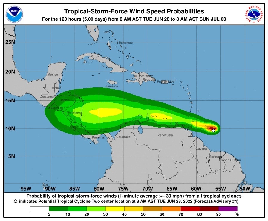
The so-called “potential tropical cyclone two” may make landfall as a hurricane in Central America next weekend, after passing through several Caribbean islands and the northern coasts of Venezuela and Colombia, according to trajectory graphics from the National Center for US Hurricanes (NHC)
According to the NHC’s numerical weather forecasting models, the disturbance has a 70% chance of becoming a tropical storm between Tuesday and Thursday afternoon, and a 90% chance in the next five days. If the projections hold up, a hurricane, possibly called Bonnie, would be forming next Friday off the Caribbean coast of Nicaragua, after hurricanes Joan (1988) and Felix (2007) followed the same route. that caused death and destruction in Nicaragua.
The NHC, based in Miami, expanded its graphics to cover until next Sunday and now the trajectory cone covers a large area of Nicaragua, parts of Honduras and Costa Rica.
The impact of hurricanes on the east coast of Nicaragua is common, since the country has a coastline of more than 500 kilometers facing the Caribbean Sea, one of the most cyclonic areas in the world.
According to the Nicaraguan Institute of Territorial Studies (Ineter), the meteorological disturbance is moving west, a trajectory that, if it continues, would take it directly towards Nicaragua.
They prepare 300 shelters
The authorities of the institutions that make up the National System for the Prevention, Mitigation and Attention of Disasters (Sinapred), and that monitor the meteorological disturbance located this Tuesday afternoon in the east of Trinidad and Tobago, began constant meetings to carry out the preparations that reduce the damage, in case the phenomenon becomes a hurricane, according to the also first lady and Vice President, Rosario Murillo.
He explained that the preparations are carried out mainly in the North Caribbean Autonomous Region (RACN), in the northeast of Nicaragua, which in 2020 was hit by hurricanes Eta and Iotain categories 4 and 5, respectively on the Saffir-Simpson scale.
The authorities of the possible impact zone have informed, through Nicaraguan government media, that they have more than 300 shelter centers ready, in case evacuations are necessary.
The Nicaraguan Army Naval Force announced that it will suspend sailings in the event of bad weather in the Caribbean Sea.
NHC statement
In its statement at 2:00 pm (Miami time), the NHC indicated that the system was about 210 miles (340 km) east of Trinidad and had maximum sustained winds of 40 miles per hour (65 km / h). , which enters the range of a tropical storm.
A westward or west-northwestward motion is expected through Thursday.
On the forecast track, the system will pass near or over portions of the southern Windward Islands on Tuesday night and will move over the southern Caribbean Sea or near the northern coast of Venezuela on Wednesday and Thursday.
Some strengthening is forecast during the next few days if the disturbance remains over water and is likely to become a tropical storm near the southern Windward Islands or as it moves west across the southern Caribbean Sea.
So far in the current hurricane season in the Atlantic, which began on June 1 and, according to the meteorological services, is going to be more active than normal, there has only been one named storm, Alex, which formed on June 5 near the Yucatan Peninsula with the remnants of Hurricane Agatha, the first formed this year in the Pacific area.


