MIAMI, United States.- The National Hurricane Center (NHC) reported this Thursday that a well-defined tropical wave was moving across the Windward Islands, bringing rain and thunderstorm activity, which could end the quiet that has been enjoyed for most of the 2022 hurricane season.
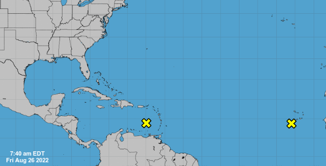
According to the report, this system is expected to move west at about 15 mph, and environmental conditions could become more conducive to its development as it moves through the central and western Caribbean Sea next week.
The probability of formation of this disturbance in five days is 20%.
For its part, another tropical system threatens the region. Also defined as a disturbance, this weather system has moved away from the west coast of Africa and is producing a large area of disorganized showers and thunderstorms.
According to the NHC forecast, environmental conditions could favor a slow development of this system early next week.
Likewise, added the forecast center, it also has a 20% chance of formation.
“We are looking at another tropical wave moving off the coast of Africa. It also has potential for slow development as it moves west across the eastern and central tropical Atlantic early next week.
Some forecasters have considered the current Atlantic hurricane season to have been relatively calm.
In this regard, Philip Klotzbach, known as the “Hurricane Guru”, said that for the first time since 1982 in the Atlantic there have been no named storms between July 3 and August 22.
The meteorologist and researcher, from the University of Colorado, assured that this “long and quiet period has been quite surprising given the robust #LaNina in the tropical Pacific and the warmer than normal sea surface temperatures of the tropical Atlantic”.
In the current season there have been only three named tropical storms and no hurricanes in the Atlantic.
For meteorologist Adam Sadvary, one of the factors that has prevented tropical systems from being activated for the last almost eight weeks is the dry and dusty air of the Sahara desert, combined with unfavorable wind shear.
“That has kept most of the Atlantic hurricane season quiet so far,” he said, adding that warm ocean waters are the most important ingredient for cyclone development.
Historically, the first part of September is the peak of tropical activity during the Atlantic hurricane season, which runs from June 1 to November 30.
Receive information from CubaNet on your cell phone through WhatsApp. Send us a message with the word “CUBA” on the phone +1 (786) 316-2072, You can also subscribe to our electronic newsletter by giving click here.








![[Galería] The largest bicycle in Colombia is in Zipaquirá. How is it? logo rcn radio](https://latin-american.news/wp-content/uploads/2022/08/Galeria-The-largest-bicycle-in-Colombia-is-in-Zipaquira-How-1024x618.jpg)

