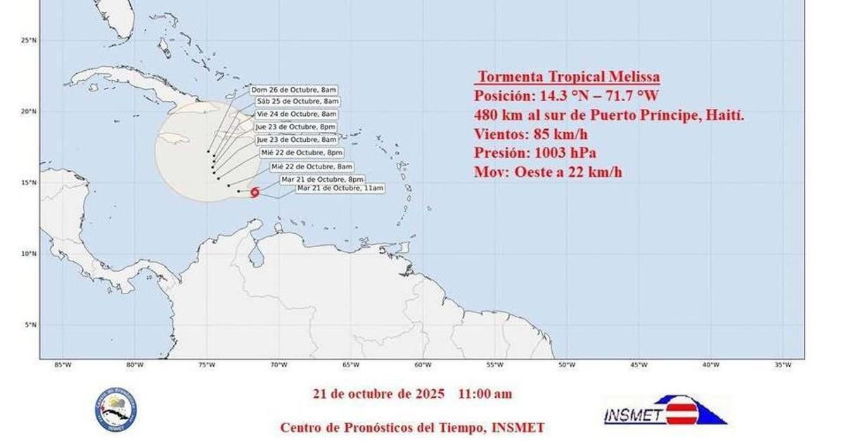
Havana/The Cuban Institute of Meteorology (Insmet) confirmed this Tuesday, at 11 am, the official formation of tropical storm Melissa over the Caribbean, about whose trajectory the government agency recognizes that there is “great uncertainty.” According to Tropical Cyclone Warning No. 1, the system was organized during the early hours of the morning from an active tropical wave and is already showing signs of strengthening.
“During the last few hours, the active tropical wave over the central-eastern Caribbean Sea has become better organized, concentrating its areas of heavy rain and thunderstorms, becoming Tropical Storm Melissa, the thirteenth organism of the current cyclonic season,” he says. the bulletin of Insmet.
At that time, Melissa’s eye was located at 14.3 degrees north latitude and 71.7 degrees west longitude, that is, about 480 kilometers south of Port-au-Prince, Haiti.
The storm has maximum sustained winds of 85 km/h, with higher gusts and a central pressure of 1,003 hectopascals. It is moving west at 22 km/h, although, according to Cuban meteorologists, its speed will begin to decrease during the day as it gradually turns northwest.
Official meteorologists claim to maintain “close monitoring of the evolution and trajectory of this system.”
The report adds that, in the coming days, Melissa will have a slow movement over the central Caribbean Sea, south of the Greater Antilles, and that the oceanic and atmospheric conditions will become more favorable for its intensification, which makes the phenomenon “a potential danger for the region.”
However, the fact that the system moves slowly and remains for several days in the central Caribbean increases the possibility that it will directly or indirectly affect the eastern half of Cuba, as previously warned by the Provincial Meteorological Center of Ciego de Ávila.
Official meteorologists claim to maintain “close monitoring of the evolution and trajectory of this system,” and have announced that the next official warning will be issued at six in the afternoon this Tuesday.
The Dominican Republic has already begun its evacuations: “The first response agencies activate their contingency plans to their fullest extent,” reported the director of the Emergency Operations Center (COE), Juan Manuel Méndez.
In that sense, “preventive evacuations are beginning” in vulnerable areas, Méndez added in a press conference with meteorology and emergency authorities. According to what was stated in that meeting by the director of operations of the Civil Defense, Delfín Rodríguez, the country has shelters for 600,000 people.
International sources, such as the United States National Hurricane Center (NHC), agree that Melissa could intensify in the coming days, with an erratic or almost stationary pattern south of Jamaica and Haiti, and a possible movement towards the northwest as a mid-level trough strengthens over the western Caribbean.
Although there is still no forecast that places the center of Melissa over the national territory, specialists insist that the associated rains, waves and coastal swells could be felt in the next few days in provinces such as Guantánamo, Santiago de Cuba, Granma and Holguín.
Most models show the system could remain in the central Caribbean for at least five days
In these regions, the structural vulnerability of homes and rural roads, together with the accumulated problems due to the lack of maintenance of dams, dikes and drainage, aggravates the risk.
International forecast models suggest that Melissa will move over very warm waters (between 30 and 31°C), with relatively weak wind shear, conditions conducive to further development. Most scenarios from the European model (ECMWF) and the US model (GFS) show that the system could remain in the central Caribbean for at least five days, with a gradual increase in its intensity. Some forecasts even warn that it could reach hurricane status if it remains over the open sea long enough.
The NHC has warned that the indirect effects – storm surges and intense rains – will already be felt in the next 48 hours over Jamaica, Haiti and eastern Cuba, while the waves and rip currents could extend towards the northern Cuban coast during the weekend.
The lack of resources to repair roofs, reinforce homes and ensure crops adds pressure to communities that face hurricanes every year with deteriorated infrastructure and few alternatives.
The experience of previous cyclones in October – such as Sandy (2012) or Matthew (2016) – reminds us that tropical systems at this time are usually treacherous: they move slowly, dump prolonged rains and cause more damage from flooding than from wind. For this reason, specialists recommend activating prevention measures now, even if the storm is still far from the Island.
