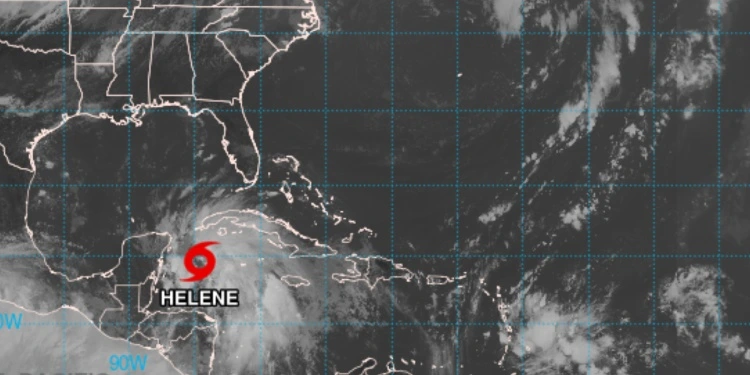
SAN LUIS POTOSÍ, Mexico.- The Forecast Center of the Institute of Meteorology (INSMET) issued This Tuesday an alert for the formation of the storm Tropical Helene, whose maximum sustained winds are 75 kilometers per hour, with higher gusts.
According to the official note transmitted by INSMET, the low pressure area located in the western Caribbean Sea continued to gain in organization and developed a well-defined closed circulation, leading to the development of Helene, the eighth tropical storm of the current season.
Analysis of its evolution indicates that at 11:00 am, the central region of the tropical storm was located at 19.5 degrees north latitude and 84.3 degrees west longitude, approximately 275 kilometers south-southeast of Cape San Antonio, at the western tip of Cuba.
Helene is moving northwest at a speed of 19 kilometers per hour and its minimum pressure is 1,000 hectopascals.
Specialists warned that in the next 12 to 24 hours there will be little change in its speed of translation, gaining more in organization and intensityHelene is expected to reach the northwestern Caribbean Sea on Wednesday morning, when it could come close to becoming a hurricane.
Rain and storm surge for Cuba
In Cuba, the system will leave heavy and intense rainfall in the western and central regions. The rains will continue through Tuesday night and Wednesday morning, and are forecast to extend into Thursday.
“From tonight, tropical storm-force winds may begin to be felt in Isla de la Juventud and Pinar del Río, with speeds between 55 and 70 kilometers per hour, which may extend from late Wednesday morning to the province of Artemisa. In the far west of Cuba, the wind force will increase from the early hours of tomorrow,” Cuban meteorologists said.
Sea levels should also be monitored, as storm surges are expected on the south coast in the west and centre, and coastal flooding in low-lying areas in the south-west could occur from Tuesday night.
Storm surge could raise water levels between 1 and 2.5 meters above normal levels along the southern coast of Pinar del Río and Isla de la Juventud, meteorologist Bryam Pérz Valdés wrote.
Showers, rain and thunderstorms are forecast for Tuesday in the western region. In the afternoon, cloud cover will increase over much of Cuba, with a high probability of showers, rain and thunderstorms in the west and center.
The rains during the afternoon and evening will be strong and intense in localities of the western region and there will be some showers and rains in inland areas and south of the eastern region.


