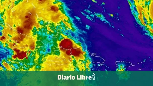
The National Meteorology Institute (INDOMET) on Saturday reported that Time conditions On the Dominican territory they will continue to be influenced by moisture and instability generated by the indirect effects of the Tropical depression number 9which, although it remains distant, continues to cause a favorable environment for the occurrence of Aguimas, thundered and winding winds in several regions of the country.
Until the early hours of this Saturday, September 27, cloudy increases are expected with scattered rainfall About the provinces:
- Peravia, San Cristóbal, La Vega, Monsignor Nouel, Santiago, San Juan, Santiago Rodríguez, Valverde, Espaillat, Puerto Plata, Monte Cristi, Elías Piña, Dajabón, Independencia, Azua, Barahona, Bahoruco and sectors of the Great Santo Domingo, among other close ones.
The rest of the territory will remain with scattered clouds partly cloudy.
For Sunday
For Tomorrow Sundaythe atmospheric pattern will remain with similar characteristics. In the morning hours They could register isolated showers in Peravia, San Cristóbal, Azua and Barahona.
While, in the afternoon and early at nightthe combination of moisture, local effects and warm wind of the south/southeast will cause Honors with thunders and wind bursts Towards the provinces of North, Northwest, Southwest, Central Cordillera and the border area.
MEEOROLOGICAL WARNINGS AND NOTICE LEVELS
Due to rains forecast, the INDOMET modified alert levels and notices by possible urban floods, floods of rivers, streams and ravines, as well as landslides.
- In alert: La Vega, Monsignor Nouel, Santiago, Dajabón, Elías Piña, Independencia, Monte Plata, San Pedro de Macorís and the Great Santo Domingo.
- Under notice: San Juan, San Cristóbal, Barahona, Peravia, Azua, Pedernales and San José de Ocoa.
- Discontinue: María Trinidad Sánchez.
Cyclonic activity in the Atlantic Basin
- HUBERTE HURRY: Category 5, with maximum sustained winds of 260 km/h, Located to 560 km nor/northeast of the Sotavento Islands. It does not represent a danger to the Dominican Republic.
- Tropical Depression No. 9: Located a 325 km northwest of the easternmost portion of Cubawith maximum winds of 55 km/h. It is given Continuous monitoring for its possible evolution and indirect effects on the country.
Forecast for Great Santo Domingo
- National District and Santo Domingo Norte, East and West: Sometimes cloudy with scattered and thundered downpours distance until the early hours of the night.
- Temperatures: Minimum between 21 ° C and 23 ° Cmaximum between 26 ° C and 28 ° C.
He INDOMET recommends the population to keep attentive to The newsletters meteorological and follow the orientations of civil protection agencies in the risk of flooding and landslides.
Aguifers, thundered and wind bursts are expected
during The next hoursespecially in regions North, Northwest, Southeast, Southwest, the Central Cordillera and border areas.


