Madrid Spain.- In the early hours of this Friday, tropical depression number nine was formed in the Caribbean Sea.
The low pressure area that transited through the southeast of the Caribbean Sea it gained in organization and became tropical depression nine of the current cyclonic season, with maximum sustained winds of 55 kilometers per hour, with higher gusts, ”said the official media Cubadebate.
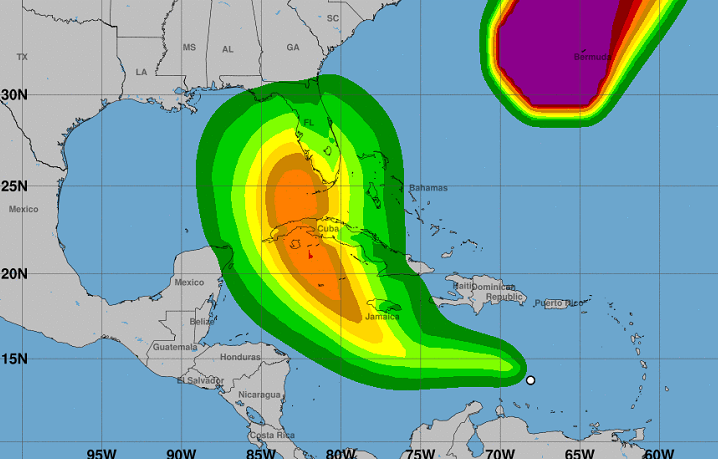
In agreement to forecast From the National Hurricane Center of the United States (NHC, for its acronym in English), during the next few hours it will gain in organization and intensity, so it could become Tropical Storm Hermine, and then a hurricane around Monday or Tuesday.
Here are the 5am AST 23 Sep Key Messages for newly formed Tropical Depression Nine (#TD9) in the central Caribbean Sea.
Interests in Jamaica, Cayman Islands, western Cuba, & eastern US Gulf Coast should closely monitor this system.
Initial Advisory: https://t.co/sH2UrRq5Wz pic.twitter.com/sXznjstWHy
— National Hurricane Center (@NHC_Atlantic) September 23, 2022
At five in the morning (Miami local time), it was about 1,105 km east of Havana and 985 km east of Kingston, Jamaica.
Tropical depression nine will bring heavy rain, flooding and possible landslides to Aruba, Bonaire and Curaçao, with heavy rain to Jamaica and the Cayman Islands in the coming days.
According to the NHC, a turn in its trajectory “further to the west, followed by a turn back to the west-northwest and northwest for this weekend” is forecast, which could affect Cuba and South Florida by Monday or Tuesday.
“Jamaica, the Cayman Islands, western Cuba, and the eastern United States Gulf Coast should closely monitor this system,” the National Hurricane Center added.
Just as he warned that the swells associated with the meteorological phenomenon “could cause waves and rip currents that endanger life.”
Receive information from CubaNet on your cell phone through WhatsApp. Send us a message with the word “CUBA” on the phone +525545038831, You can also subscribe to our electronic newsletter by giving click here.
