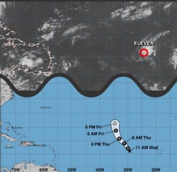
This Wednesday morning the depression tropical number 11, in the center of the Atlantic tropicalreported the director of National Meteorological Office, Gloria Ceballos.
Weather reports indicate it is possibly a storm tropical of short duration and has the name Julia.
Due to its position it is expected that it will not affect any country.
You might be interested in reading: Hurricane Ian approaches the west coast of Florida
Most recent report from ONAMET
The trough in the middle and upper levels of the troposphere will be getting closer to the country, so we will again witness, especially in the afternoon, downpours with electrical storms and gusts of wind, over towns in the southeast (including the Great Saint Domingo), southwest, the Cordillera Central and other points in the border area. While for the northeast, some local showers with isolated thunderstorms are expected. These precipitations will be present until the early hours of the night.
For tomorrow Thursday, The aforementioned trough will continue to dominate atmospheric conditions, causing weak to moderate rains with isolated thunderstorms, during the first hours of the day, towards some locations on the Atlantic coast.
As for the afternoon, moderate to heavy showers, electrical storms and gusts of wind will be generated, especially La Altagracia, El Seibo, Hato Mayor, Monte Plata, Santo Domingo, La Vega, San Juan, Elías Piña, San José de Ocoa, among others.
