SLP, Mexico.- Meteorologists have informed on Cuban Television about the dangerous Hurricane Rafael, which is about to make landfall in Cuba after reaching category 3 on the Saffir-Simpson scale.
During the national television news this noon the experts They warned that there will be heavy, intense rains and the hurricane is moving towards the northwest, towards Pinar del Río.
This was reported by Dr. José Rubiera who transmitted an explanation about the meteorological event that impacts Cuba.
Rubiera, consulted by specialists from the Institute of Meteorology (INSMET), specified that Rafael will take a trajectory further west than expected and will cross the eastern part of the province of Pinar del Río.
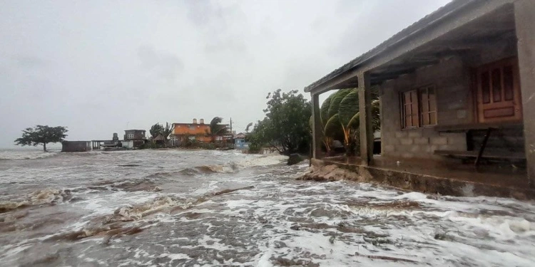
Hurricane-force winds, storm surge, coastal flooding and sea level rise may occur, causing storm surge.
For his part, meteorologist Elier Pila stressed that Rafael has maximum sustained winds of 185 km/h and is a very dangerous hurricane.
Its center is expected to enter Cuban land at some point between the provinces of Artemisa and Pinar del Río.
Rafael reached category three on the Saffir-Simpson scale around noon this Wednesday, as it approaches the western coast of Cubaas reported by the United States National Hurricane Center (NHC) in your 1:00 p.m. bulletin
The powerful cyclone is expected to bring life-threatening storm surge, intense winds and flash flooding to portions of western Cuba, the NHC warned.
At 1:00 in the afternoon, the center of Rafael was located at 22 degrees North latitude and 82.3 degrees West longitude, about 65 kilometers northeast of the Isle of Youth and approximately 135 kilometers south. of Havana.
The Cuban provinces of Pinar del Río, Artemisa, Havana, Mayabeque, Matanzas and Isla de la Juventud are under a Hurricane Warning. For their part, Villa Clara and Cienfuegos are under Tropical Storm Warning. “A Hurricane Warning means that hurricane conditions are expected somewhere within the warning areas,” the NHC explained.
