After a week marked by storms and the passage of an extratropical cyclone, The state of São Paulo is expected to continue facing unstable weather in the coming days due to the slow passage of cold weather. According to Civil Defense, this system should cause persistent rain, lightning, gusts of wind and even hail across the entire territory of São Paulo between this Saturday (13) and next Tuesday (16).
The National Institute of Meteorology (Inmet) placed a large part of São Paulo on orange alertinforming that the region may face rainfall between 30 and 60 millimeters per hour (mm/h) or 50 and 100 mm/day, intense winds that can vary between 60 and 100 kilometers per hour (km/h), and hail between today (13) and tomorrow (14). The orange alert is the second most serious on the scale used by Inmet, below only the red alert, and signifies a dangerous situation.
According to Civil Defense, the regions of the state that are likely to suffer most from these conditions are Presidente Prudente, Marília, Bauru, Araraquara, Campinas, Sorocaba, Itapeva and Registro.
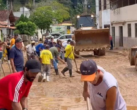
This Saturday, the agency said, the southern, central and eastern regions are expected to experience greater instability, with greater rainfall expected.. According to Civil Defense, this increases the risk of flooding, floods and other disturbancesespecially in more vulnerable areas. The forecast is that, starting this afternoon, heavy rain showers may occur in the municipalities of the regions of Marília, Presidente Prudente, Itapeva, Bauru, Registro, Vale do Paraíba, Baixada Santista and the metropolitan region of São Paulo.
For tomorrow (14), the forecast is that the cold front will remain on the coast of São Paulo, keeping the weather closed and rain frequent throughout the day. The risk of flooding and landslides increases, especially in more susceptible municipalities.
From Monday (15), the system begins to advance towards Rio de Janeiro, but will maintain persistent rain in several regions of the state of São Paulo.