If a person wishes to move from Elías Piña to a province in the north of the country, it will take an average of approximately seven hours and 30 minutes, due to the need to go around the Cordillera Central mountain range.
The mostly lonely International Highway, whose 48.3 kilometers serve as a natural border between the Dominican Republic and Haiti, could be an alternative to connect these provinces, but it is not considered a main road due to its poor condition since most of its route is unpaved.
This is one of the examples cited by the Ministry of Economy, Planning and Development when it analyzes the natural and road connectivity barriers presented by the border provinces that prevent, to a certain degree, the reduction of the existing socioeconomic gap in that area.
“It is impossible to talk about development without reaching minimum conditions of connectivity”, indicates the ministry in its report border monitor corresponding to this month of April, in which it stands out that in Elijah Pineapple and Pedernales There is the need to expand the existing road network by more than 50% to achieve integrated connectivity.
as natural barriers Montecristi, dajabón Y Santiago Rodriguez they have the Cordillera Central; Elijah Pineapple that same mountain range and the Mountain range of Neiba; Bahoruco and Independence also to the Sierra de Neiba and the Sierra de Bahoruco; and Pedernales also to the Sierra de Bahoruco.
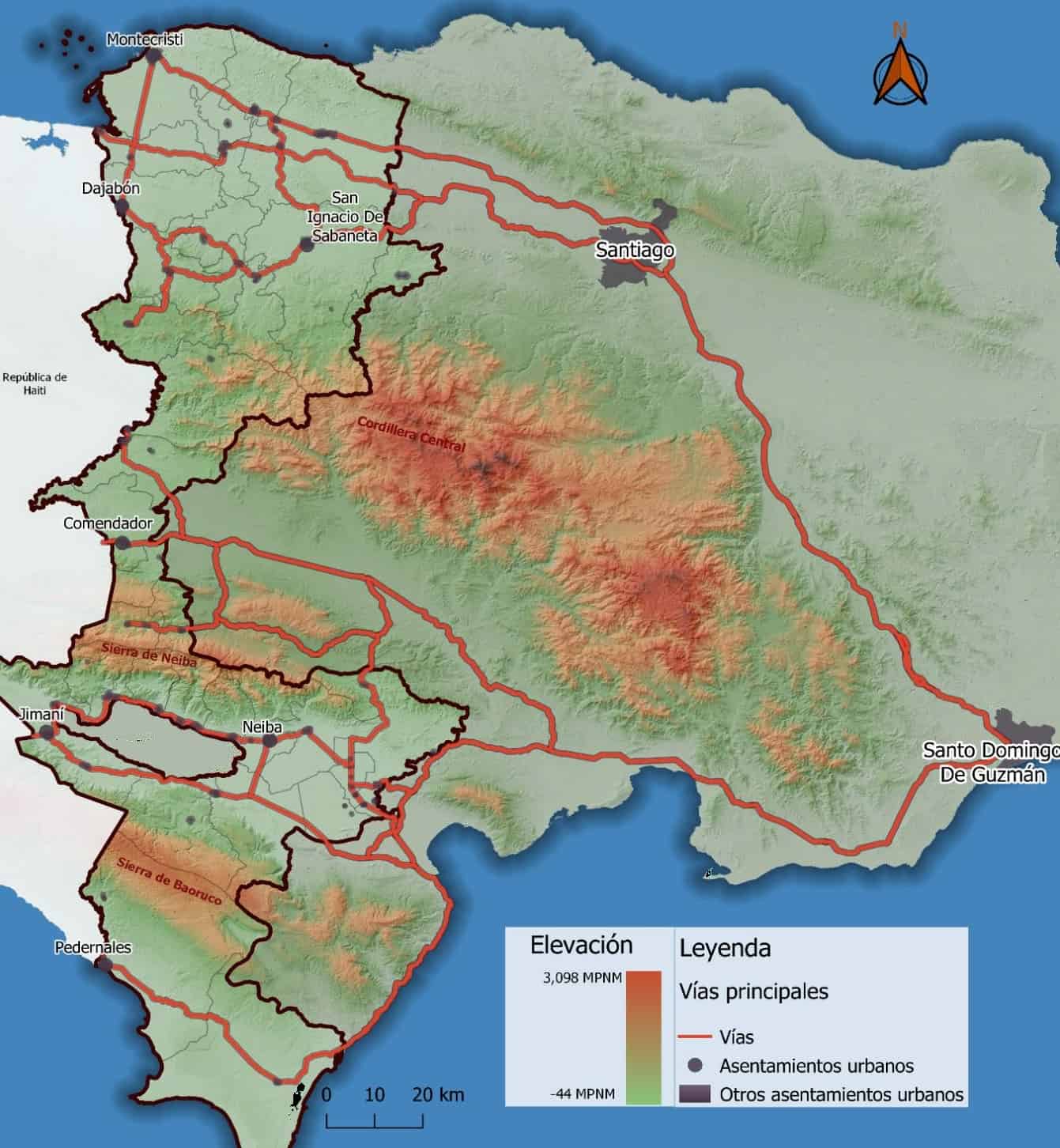
In the Border Monitor report for this April, the Ministry of Economy highlights that the limited road connectivity in the border areawhich is accentuated in the southern and central parts, makes it difficult to integrate the main urban centers within the border areawhich prevents, to a certain degree, the reduction of the existing socioeconomic gap.
He points out that the provinces of the border area they have geospatial and connectivity characteristics that limit their productive potential and integration with the national economy. In addition, excessive travel times, translated into high transportation and logistics costs, generate disincentives for companies to establish themselves in the territory, which encourages the emigration of families to large cities, further isolating border communities.
Pedernales, Bahoruco and Independencia and the center (Elías Piña), present superior travel times when compared to any other region of the country, calculates the Ministry of Economy.
The access roads to and from the main development poles (Santo Domingo and Santigo) with the provinces in the south and center of the border are trunk road number two (Sánchez) and regional road RD-44 (Enriquillo), which are predominantly single lane in each direction of the road throughout its length.
The estimated average time to and from these provinces is approximately four hours and 15 minutes for Santo Domingo and six hours to Santiago.
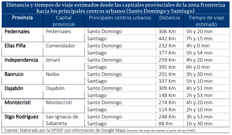
The Ministry of Economy observes that Elías Piña has disconnection between his own six municipalities. It does not have a main road in good condition that directly connects the cities of the north with those of the center and south.
Last March, the government approved the reconstruction project of the Comendador-Guaroa highway, in Elías Piña, for 316.4 million pesos, to be executed by the Ministry of Public Works, according to a document from the General Directorate of Public Investment of the Ministry of Economy.
In the case of Pedernales, its more than 60% territory within protected areas limits the development of road infrastructures that connect it with other urban centers.
The Ministry of Economy highlights the need to build the RD-47 highway and the improvement of the Enriquillo-Pedernales section. This would impact 17 kilometers of highway and considerably reduce the time and costs associated with the journey.
“This measure is transcendental for the Cabo Rojo tourism project since it would facilitate the arrival of tourists with a spillover effect on the local economy, job creation and increased foreign exchange,” he says.


