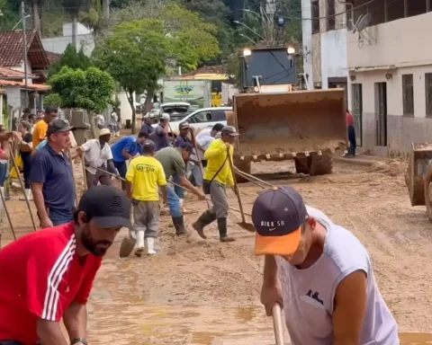
The Civil Defense of the State of Rio de Janeiro issued this Sunday (4) an alert for the occurrence of intense rains with lightning in all municipalities in Rio de Janeiro, due to the operation of a South Atlantic Convergence Zone (ZCAS). The warning is valid from 8am this Sunday (4) until 6am on Monday (5).
According to Civil Defense and the State Natural Disaster Monitoring and Alert Center (Cemaden-RJ), isolated rain showers of moderate to heavy intensity are forecast.
The guidance is that the population follows updates from official bodies and follows the recommendations of the local Civil Defense and the municipal contingency plan. In case of emergency, telephone 199 or 193 must be called.
The Operations and Resilience Center of Rio City Hall (COR-Rio) reported this Sunday (4) that the city of Rio de Janeiro entered Stage 2 at 8:07 am, due to records of rain and strong winds in the region of the Tijuca massif, which comprises the Tijuca Forest.
According to the Rio Alert System, centers operating in the Center region, north zone and Guanabara Bay lost intensity in the early afternoon. Other isolated nuclei remain operating over the southwest zone and the Tijuca Massif. Moderate to heavy rain showers are forecast at any time.
At 8am this Sunday, the Civil Defense of the municipality of Rio activated three sirens in the community of Formiga, in the north of Rio, due to the large volume of rain. At 9:15 am, the sirens were silenced, after there was no record of heavy rain. The Alert and Alarm System has 164 pieces of equipment in 103 communities in the city.
In the mountainous region of Rio de Janeiro, The Civil Defense of Petrópolis issued, at 11:35 am this Sunday (4), an alert via SMS for the forecast of moderate to heavy rainwhich may be accompanied by lightning and gusts of wind in the city.