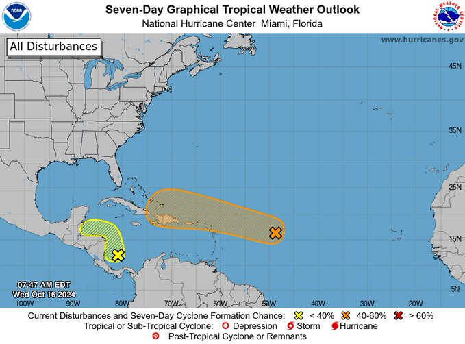
The director of the Dominican Institute of Meteorology (Indomet), Gloria Ceballos, reported this Wednesday that starting next Friday the rains will increase, due to the approach of a tropical disturbance to the country’s forecast area, which moves over the Atlantic. east-northeast of Puerto Rico.
In the most recent report, the Indomet He specified that “as it approaches our area, it will cause cloudy morning hours with downpours, thunderstorms at times and gusts of wind over towns in the east and northeast of the country, which during the afternoon and early hours of the night will become “They will extend to the southeast (including Santo Domingo), northwest, Central mountain range and the border area.”
Meanwhile, the incidence of a high pressure system in the North Atlantic Ocean will be limiting the humidity content over the country, according to the report, favoring a slightly cloudy, hot sky with little precipitation activity in much of the national territory. Only the southeast wind and the effects of diurnal and orographic warming could cause isolated showers over Monte Cristi, Dajabón, Santiago Rodríguez and Elías Piña, which will last well into the night of this Wednesday.
“Tomorrow Thursdaythe high pressure system will continue to generate good weather conditions in most locations in the country, however, the predominant easterly wind will carry some passing clouds during the early morning that will leave isolated showers in Samaná, Hato Mayor, El Seibo and San Cristóbal, while in the afternoon, the combination of the wind with the daytime warming will produce occasional cloudy increases with local downpours and isolated thunderstorms towards Monte Plata, Hato Mayor, Sánchez Ramírez, Monseñor Nouel, La Vega, Azua, San Cristóbal and El Gran Santo Sunday, especially the northern portion,” published Indomet.


