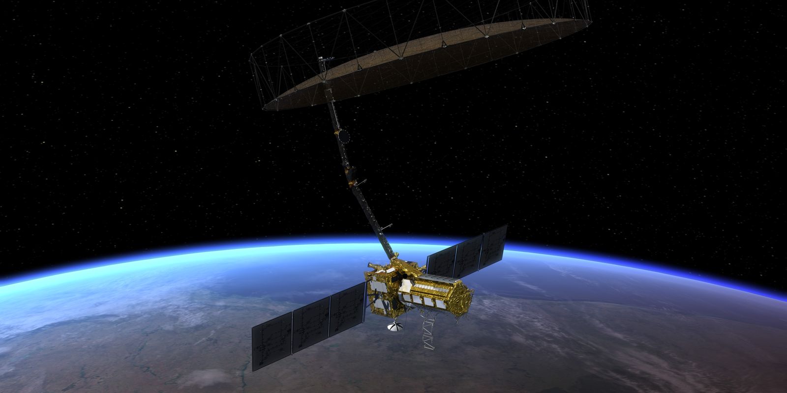
Petrobras will have another means to guarantee greater security in oil exploration in the Equatorial Margin, in the stretch of the states of Amapá, Pará and Maranhão. The company was accepted into the Early Adopters Program of the NASA-ISRO Synthetic Aperture Radar (Nisar) mission. The system is unique in collecting Synthetic Aperture Radar (SAR) images via satellite for Earth observation.
Engineer Fernando Pellon, senior consultant in the Geochemistry Management of the Petrobras Research, Development and Innovation Center (Cenpes), explained that in floodable regions, mangroves are very sensitive ecosystems to oil spills, so information from oil spill sensitivity maps.
“This mapping of the region where the mangroves are flooded or not, and when they are flooded, is important information to carry out an oil spill sensitivity study and to map the biota that is living in that location. These are two practical applications of Petrobras’ mission and objectives”, he informed in an interview with Brazil Agency.
The project will be developed by the American space agency and the Indian Space Research Organization, scheduled to begin in 2025, when the Brazilian oil company will also start using the images in its Environmental Geochemical Observatory of the Brazilian Equatorial Margin (ObMEQ) project.
Petrobras will represent one of the 100 projects in the mission. On the company’s part, the intention is to monitor the marine and coastal environment in the section of the three states on the Equatorial Margin, in addition to updating the mapping of this coastline.
“This is a technology that allows information about a specific target without physical contact with it. For example, it can remotely measure the temperature of the sea surface, it can remotely check whether a plant is green or water-deficient, it can identify the chemical and mineralogical constitution of a rock. This is all possible by receiving electromagnetic radiation from the top of the Earth”, he explained.
Climate change
For the engineer, monitoring will also allow him to monitor climate changes. “The satellite orbits 747 kilometers from Earth and will obtain images every six days of a certain point on the Earth’s surface. There will be almost continuous coverage of all immersed and ice-covered areas. It’s a very interesting mass of data. It will have information on biomass, natural disasters, sea level rise, underground water and will have two sensors. One from NASA in the so-called L band and one from the Indians with a shorter wavelength in the S band,” he said.
“One of the relevant points of the mission, precisely, is to provide subsidies around climate change and its impacts, both physical means such as rising sea levels and melting of the ice cover, as well as the impact on vegetation and urban dynamics. In all of this, it will provide very valuable information for this type of work”, he pointed out.
According to Pellon, it is currently common to make assessments based on aerial photographs, optical images that appear, for example, on Google Maps. The engineer added that these images are acquired in the visible range, that is, they receive energy from wavelengths that allow human eyes to see. However, there are other bands of the electromagnetic spectrum in which radiation also exists and is not perceived. With this program it will be possible to obtain images for analysis, even if the sky is covered by clouds, which is not the case with other systems.
“One of them is infrared, which provides information about the mineralogical and chemical construction of rocks. We don’t see it, but this information is available and sensors on planes or satellites are capable of capturing it. However, for this spectrum band clouds constitute barriers, because these sensors measure the energy reflected by the sun. If the cloud is in the way, it is a barrier and the sensor can only pick up the energy reflected by the cloud. The image is full of clouds”, he observed.
The Cenpes consultant provided another significant application of the system. “Another advantage of the radar system is that as it has its own energy, it can acquire images at night, because it does not depend on sunlight. It’s like a flash. You can make the image in the dark by making a comparison.”
Rio Grande do Sul
As the satellite will be able to provide continuous coverage over the entire immersed area of the globe, the engineer said it can also help in assessing the impacts that Rio Grande do Sul faced after the environmental disasters of May this year.
“There will also be data from this region, which is why it is such an important mission,” he said, highlighting that the importance of information increases as it is shared.
“The great thing today is sharing, you grow much more by sharing than by excluding. In fact, this issue of climate change is a matter of global interest, and all information from anywhere in the world is important,” he said.
The ObMEQ project is one of 13 carried out by Cenpes in the area of sustainability and environment for the Equatorial Margin. According to Petrobras, they are developed in a network by several institutions, with the participation of universities and other groups in the region, as is usually the case in the company’s research partnerships.
Transparency
In the company’s view, the project will have transparency as it will provide an always updated configuration of the Equatorial Margin coastline, available for use not only by different areas of Petrobras, but also by environmental bodies and society, according to the needs of each one.
“An additional use of the Nisar Mission data concerns the detection of oil slicks on the sea surface, both of natural origin [exsudações] as anthropic [derrames]”, he explained.
The ObMEQ project, according to the company, is the result of a partnership between Cenpes and an ecosystem of universities and institutions in the North-Northeast, led by the Federal University of Pará (UFPA).
“Cenpes’ participation in the Nisar Mission Early Adopters Program is a seal of scientific quality for the ObMEQ Project, proof that Petrobras and its academic partners in Brazil are articulated with the most advanced in the international scientific community. The collaboration between Brazilian and NASA scientists will be an important contribution to the acquisition of scientific knowledge necessary for systematic environmental monitoring of the coastal mangrove zone along the Equatorial Margin”, he said.
