Areas of instability that are expected to form in Paraguay, starting this Thursday afternoon (11), will advance towards Paraná causing rain, wind and the possibility of hail. According to Danilo Siden, meteorologist at the National Institute of Meteorology (Inmet), the tendency is to change the climate in this state in the Southern Region from dawn onwards.
“The areas of instability, which should form in Paraguay in the afternoon or evening today, will advance and throughout the morning they should begin to reach Paraná from today to tomorrow”, he informed the Brazil Agencyhighlighting that the amount of heavy rain is relevant.
“We have a warning of the possibility of rain above 100 millimeters (mm) from tomorrow, occasionally strong gusts of wind and hail. The gusts should exceed 50 kilometers per hour”, he informed, adding that the rain should already be felt between dawn and the morning of this Friday, continuing until Saturday.
“From Saturday this area [de instabilidade] it should head from Paraná to São Paulo, south of Minas and south of the state of Rio.”, warned the Inmet meteorologist.
Other states
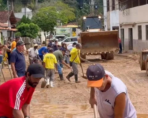
The south of Minas Gerais, north of Rio de Janeiro, São Paulo, Santa Catarina and Espírito Santo will still record heavy rain as an effect of the extratropical cyclone that began to act in the south of the country on Monday (8) and caused damage in Rio Grande do Sul, Paraná, Santa Catarina and São Paulo.
According to Siden, although the cyclone is further away in the ocean at the height of Rio Grande do Sul, it still changes the weather conditions in some regions.
“The strong gust continues today, but less intense than yesterday. The warning is 50 kilometers per hour”, he pointed out.
The meteorologist added that Inmet will release, on Thursday afternoon, a warning summarizing the climate situation in the country due to the effects of the extratropical cyclone.