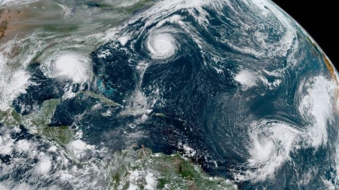
Santo Domingo- The director of the National Meteorology Office warned that the cyclonic season that begins this Wednesday finds the waters of the Atlantic Ocean hot due to the effects of La Niña, and that is the energy that tropical cyclones need to form and intensify. and put an end to a phenomenon that can be dangerous for the land area.
Engineer Gloria Ceballos explained that the institutions that manage emergencies, that is, the meteorological services of the Caribbean and the North Atlantic, have prepared for a more active than normal cyclone season.
Ceballos said that it is normal for 14 named storms to form in a season, however, the projections made by universities, as well as the National Office of Oceanic and Atmospheric Administration (NOAA), among other agencies specialized in this type of analysis, They predict that this year there will be between 14 and 21 named storms, and of those between six and ten can reach the category of hurricane, and of those between three and six could be intense hurricanes.
Interviewed on the D’Agenda program, the official said that one must be prepared because the Dominican Republic is in the Caribbean, on the path of hurricanes, and that is why
It urges the population to be aware of early warnings that imply early prevention.
He recalled that last year a slightly above normal season was projected and ended with 21 named storms.
“And, although people tell me that 21 were formed but we were not directly affected, we have to think that we are not always affected, even though the hurricane season is very active, but that we must always be prepared”, explained the director of the Onamet.
We recommend you read: ONAMET forecasts for this Friday cloudy with downpours and hot temperatures
He insisted that last season 21 named storms were formed, although a maximum of 18 were projected, and what happens is that these forecasts, according to the conditions that are presented in the atmosphere and the environmental conditions, can be coupled as in which the hurricane season is fully entered, because at the beginning the projections are made and in the middle some adjustments are made, if those conditions favor more than what had been projected.
“We are with La Niña, which is the cooling of the Eastern Equatorial Pacific, when we have this cooling of the waters of the Pacific, then we have the warmer Atlantic, this is the energy that tropical cyclone-type phenomena need to form, intensify, and give to ruin a phenomenon that can be dangerous for the land area, then in the analyzes that are done prior to the cyclonic season, it is taken into account if we have El Niño or La Niña”, argued the expert in weather forecasts.
Say that, on the other hand, when there is the El Niño phenomenon, “as it was here in 2014 and 2015, the cyclonic seasons were not very active, and in the case of La Niña, as happened in the Dominican Republic in 2017, we have seasons very active cyclonic storms.
“Because the Atlantic has enough energy to fuel these disturbances and turn them into intense hurricanes,
also the winds in heights are weak and that favors that these phenomena grow more easily, that is, after the disturbance forms, that we already have the cyclonic circulation, when the winds in the upper levels of the atmosphere are weak, they allow that these systems continue to grow and develop as intense hurricanes,” said the forecaster.
He recalled that, in the cyclonic season of 2017, which coincided with the La Niña phenomenon, quite strong hurricanes such as Irma and María were formed.
Ceballos said that, historically, the hurricanes that have hit the Dominican Republic, and caused the most damage, have formed in the Cape Verde Islands, in West Africa.
He says high temperatures coupled with humidity and dust from the Sahara produce a wind chill of 40 degrees Celsius
The engineer Gloria Ceballos highlighted the high temperatures that were recorded in the months of April and May that broke records at a global level, and although that did not happen in the country, the heat that people felt was 40 degrees Celsius, since the temperature was in 36 degrees, but the relative humidity of the air and the effects of dust from the Sahara were added.
“That was worldwide, in India there was an extraordinary situation of record temperature of which there was no record, in several provinces of Spain the same situation occurred, between the end of April and the first days of May, and we have not stayed ago, the temperatures have not broken records of previous years but they have been high, and what situation makes the temperature here in the coastal area feel warmer than what is actually being recorded, is due to the wind chill” , expressed the director of Onamet.
He said that “the relative humidity in the coastal zone is higher than inland areas, despite the fact that temperatures
They reached 36 degrees, the thermal sensation that the body experienced exceeded 40 degrees and that is why many people were practically desperate for the heat, and the dust from the Sahara contributed to that hot environment.
He added that this cloud of dust from the Sahara that moves in the summer months, now in May, after the first cloud that affected the country, the population must be aware that these clouds will continue to move throughout the summer.
“Because, in addition to the Eastern Waves are going to increase, we have the African Monsoon that is favoring these tropical wave type disturbances, they are called Eastern Wave because they come from Africa, behind them comes that cloud of dust from the Sahara and that contributes to having more heat because the atmosphere is drier when the concentration of dust from the Sahara is high, ”said the official.
He recommended to the population that, when the country is under the influence of the dust clouds of the Sahara, not to expose themselves in the hours of greatest insolation, not to do strong sports, and those who suffer from allergies, their respiratory situation worsens, mainly those who suffer from of asthma
Gloria Ceballos recalled “that in the alerts issued by the National Meteorology Office, when there is a moderate concentration of Dust from the Sahara, people are asked to wear masks, although in the pandemic it is mandatory, when dust clouds arrive from moderate to strong, it is important that masks are used ”.
