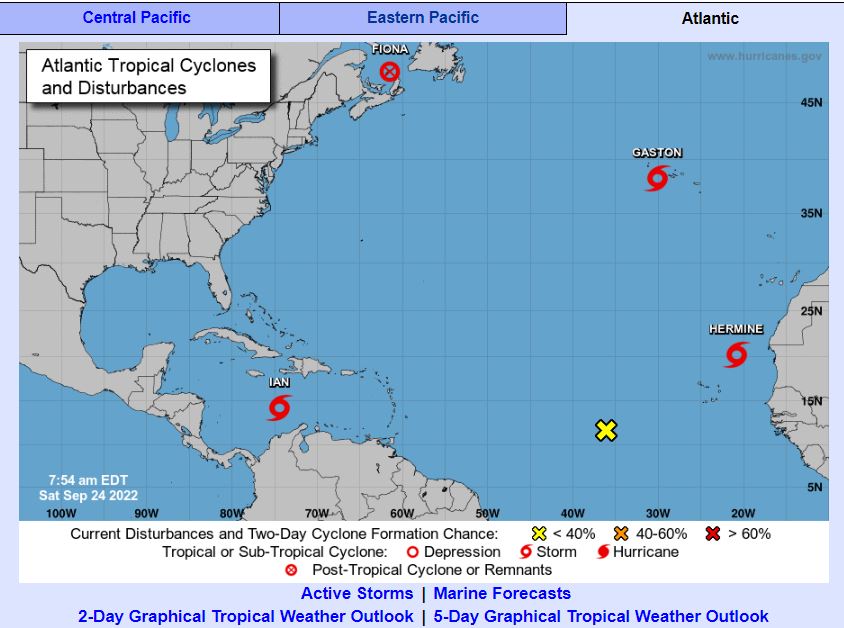
Santo Domingo – The National Meteorological Office reported that during the night tropical depression number 9, became the tropical storm ianwhich will continue to induce indirect effects on the country.
From the early hours of the morning there will be clouds accompanied by light to moderate rains, being strong at times with electrical storms and isolated gusts of wind over different provinces located in the northwest, northeast, southeast, southwest, Cibao Valley, Central Cordillera regions. , including the (Greater Santo Domingo).
This precipitation activity will be more frequent and intense towards other locations in the afternoon as this system advances to the west.
Onamet indicated that tomorrow, Sunday, cloudy fields will remain from the early morning hours producing locally moderate to strong downpours with electrical storms and occasional gusts of wind towards the towns of the northwest, north, southwest and central mountain ranges, induced by the indirect effects of Storm Ian, and an upper trough.
Tropical storm Ian was located about 510 km southwest of Kingston (Jamaica), moving at about 22 km/h, with maximum sustained winds of 75 kph, with higher gusts. It is expected to continue moving over the Central Caribbean.
In another order, about Tropical Storm Gaston, the agency said that it is located about 130 km west of central Faial of Azores, has maximum sustained winds of 85 km / h, moves west / northwest at about 15 kph. Due to its position and displacement, it does not represent a danger to the country.
An area of downpours with electrical storms associated with an active tropical wave is also being monitored, which is located thousands of kilometers west/southwest of the Cape Verde Islands, currently with low potential (20%) to become a cyclone. tropical for the next 48 hours. Due to its position and displacement, at the moment it does not represent a danger to the Dominican territory.
Hurricane FIONA
On Hurricane Fiona, Onamet reported that it is degenerating to a post-tropical, located about 255 km northeast of HALIFAX (NOVA SCOTIA), with maximum sustained winds of 150 kph and moving north at a speed of 43 kph. While tropical storm Hermine is located about 575 km northeast of Cape Verde, with maximum sustained winds of 65 km/h and is moving east at about 17 km/h.
Due to the saturation of the soil, as well as the rainfall that has occurred and is forecast, the ONAMET maintains levels of NOTICES Y ALERTS weather forecasts for possible flooding of rivers, streams and ravines, as well as urban flooding and landslides in the following provinces:


