The National Center for Monitoring and Natural Disasters Alerts (Cemaden) launched, on Monday (17), in São José dos Campos (SP), the system of prediction of landliness risk, the so -called Georisk. For Minister Luciana Santos (from Science, Technology and Innovation), the technology created places the country “in the forefront of anticipation of risk”. 
According to the minister, the tool is innovative, has the potential to save more lives and to avoid material losses, which have become frequent in a moment of climatic extremes. Luciana Santos explained that Georisk was a priority work of Cemaden to avoid more disasters and tragedies.
Cemaden researcher, engineer Pedro Camarinha states that since the beginning of the tests with Georisk, the system has been able to detect 90% of the main disasters associated with landlies. He explains that the system has been improved over three consecutive summers, through statistical tests and machine learning calibration, which increased the accuracy of the system.
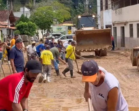
Minister Luciana Santos evaluates that climatic extremes require answers like this of scientists. “There is a process that already affects us with heavy rains, floods, dried, hot waves, with impact on various sectors and our ways of life.” She warned that these events will get worse and this charges “coordinated and urgent” actions. The minister also mentions that the country has an uncontrolled urban development, which aggravates the situation. “More than 80% of the Brazilian population in this continental country lives in urban centers and often in areas of risk, or in hills or flooded.”
Currently, CEMADEN covers 1,133 municipalities in Brazil (of which 1,083 already have specific risk thresholds identified). It is expected that, by the year 2026, expansion to 762 municipalities, and thus reaching 60% of the population of the country where people are in a higher risk situation. The Brazilian disaster prevention system will be presented at COP 30 in Belém, according to Minister Luciana Santos. Georisk has been calibrated to offer results at both regional and municipal level.
Budget prevention
Minister Jader Filho (cities), also present at the platform’s announcement event, points out that prevention is the main way to reduce the chances of disasters and that when the current government took over, there was no good resources. Jader Filho mentions that “many restraint works on slopes and drainage” had been paralyzed, for example.
“Prevention needs to be in the budget of all entities of our Federation,” he argues. He quoted the tragedy in Rio Grande do Sul last year, where more than 180 lives were lost.
Cemaden researcher Pedro Camarinha, who has been ahead of the platform’s development, explains that Georisk may indicate, from data from different sources gathered, that the chance of landslides may be higher in one region than in others. “We here, within the situation room, know how to interpret risk forecast bulletins in a very well directed way.”
Permanent evaluations
Camarinha adds that the data are also observed from the historical point of view of rain preceding up to seven days. “We coupling multiple time forecast models based on critical precipitation thresholds, which greatly increase the chances of landslides, and applies an equation by combining all these models,” he details.
A job then is to evaluate, over time, how much this Geraisk result is hitting or making a mistake. “We can only do this because we have a occurrence registration database. If we are signaling that a region has a high risk, nothing fairer than evaluating the next day if there was the occurrence to be able to mark and calibrate the system. ”
Thus, experts seek to detect more events that cause landslides in order to send less inaccurate or false alerts. The tool, according to the expert, is an improvement of activities. “A great advantage is that today we can deliver quality data three days in advance. We are following, over the days, whether that risk remains or not. ”