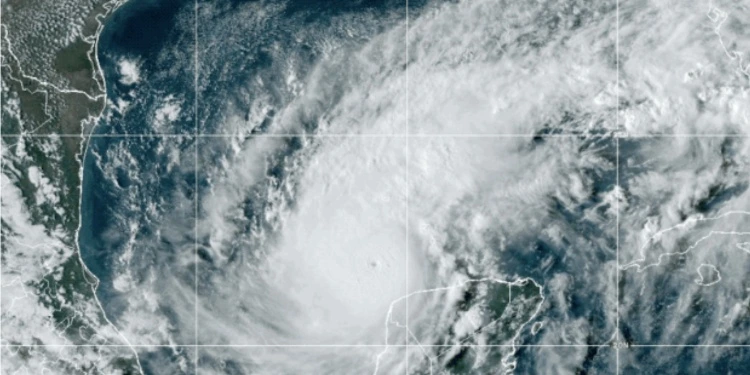
SAN LUIS POTOSÍ, Mexico.- Hurricane Milton became the strongest in the Gulf of Mexico since Hurricane Rita in 2005, the National Hurricane Center (NHC) of the United States, based on the wind speed of the atmospheric phenomenon. Due to its pressure, Milton is also the fifth most intense hurricane recorded in the Atlantic basin and the second Category 5 hurricane this season.
Since Sunday, experts warned, Milton increased an additional 95 mph (152.8 km/h), more than double the rapid intensification requirement. This figure has been surpassed only by Wilma 2005 and Félix 2007, according to NHC records. Maximum sustained winds peaked at 180 mph (289.6 km/h) Monday afternoon.
Currently, it has maximum winds of 270 kilometers per hour, with higher gusts and during the last hours the minimum pressure has dropped to 905 hectopascals, said the Forecasting Center of the Cuban Institute of Meteorology.
“Milton has the potential to be one of the most destructive hurricanes on record for west-central Florida,” warns the NHC. Additionally, the National Weather Service in Tampa, Florida, is warning that “if Milton continues its course this will be the most powerful hurricane to hit Tampa Bay in more than 100 years. “No one in the area has experienced a hurricane this strong before.”
Flight cancellations before Milton
Several US airlines had their departures and arrivals through Milton affected, including JetBlue, Frontier, Southwest, Delta, United, American and Spirit.
Tampa International Airport announced the temporary closure of its operations starting this Tuesday, to reopen “when it is safe to do so.”
St. Pete-Clearwater will close after the last flight on Tuesday and will remain closed on Wednesday and Thursday.
For its part, that of Miami He specified that it remains open but urged passengers to be attentive to their flights.
#WeatherAlert: While #FLL is not currently within the direct path of #HurricaneMilton and remains open, we are monitoring the storm for inclement weather that is likely to impact our region as it moves closer to the Gulf Coast of Florida. We will provide updates if this forecast… pic.twitter.com/mP16uQGhaG
— Fort Lauderdale-Hollywood Int’l Airport (FLL) (@FLLFlyer) October 7, 2024
The one in Sarasota confirmed that it closed this Tuesday afternoon and asked to consult the respective airlines to obtain information about the status of the flights.
Other airfields, such as Fort Lauderdale-Hollywood (FLL), are attentive to the advance of Milton even though it is not in the direct path of the hurricane.
Our CEO, Kevin J. Thibault, held a press conference to discuss preparations for Hurricane Milton. Media got a behind-the-scenes look at our crews’ first steps in hurricane readiness, including securing passenger boarding bridges to ensure safety. pic.twitter.com/Jr888wCcim
—Orlando International Airport (@MCO) October 7, 2024
Evacuations in Florida
Officials in Pinellas County, which includes the cities of Clearwater and St. Petersburg, said storm surges of up to 15 feet are expected and have issued mandatory evacuation orders for more than 500,000 residents.
Evacuation orders are in effect for people in vulnerable areas and all mobile homes in the county. Pinellas County Emergency Management Director Cathie Perkins said it’s a matter of urgency.
With winds of 170 mph, the storm could make landfall Wednesday night in the Tampa Bay metropolitan area, with a population of more than 3.3 million people.
Eleven Florida counties are under mandatory evacuation orders and have about 5.9 million residents.
Risks for Cuba
The Meteorological Institute of Cuba (INSMET) indicated in a newsletter that the first effects caused by Hurricane Milton on the Island began to be felt in the western region of the country since Monday night, with moderate winds, rains and dangerous waves.
The provinces of Pinar del Río, Artemisa, Havana, Mayabeque and Isla de la Juventud will experience sustained winds of between 25 and 40 km/h, with higher gusts of up to 50 km/h in Pinar del Río. According to the weather report, the waves on the southern coast of the western region are expected to gradually increase to swells, which could cause light to moderate coastal flooding.
In addition, weather conditions will remain unstable throughout this Tuesday due to the feeding bands of the cyclonic system.


