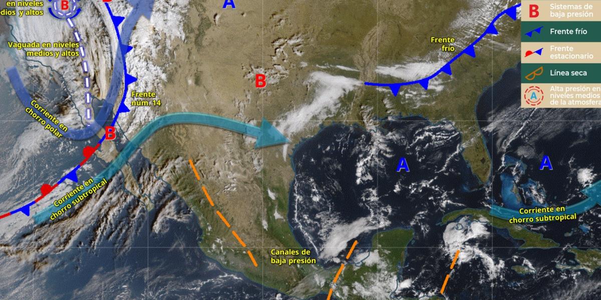
This week starts with marked winter conditions in much of the country since, according to the extended forecast of the National Meteorological Service (SMN), two active cold frontsa trough at medium and high levels and a cyclonic circulation will maintain a scenario of low temperatures, strong wind, rain and potential for snow between this Monday, November 17th and Thursday, November 20th.
The The most affected regions will be the Northwest, North, South Pacific and Southeast, in addition to the Yucatán Peninsula, where episodes of intermittent rain are expected during the next four days.
In contrast, the environment will remain very cold in the mornings and nights over the North Table and Central Table, with frost at dawn.
Monday: new cold front approaches
This Monday the 17th, a new cold front will approach the northwest, while the cold front 14 It will continue to move over the north of the country. Both systems, interacting with the jet streams, will cause:
- Heavy rains (25-50 mm): Baja California (north) and Chiapas.
- Showers: Sonora, Michoacán, Guerrero, Oaxaca, Tabasco, Campeche, Yucatán and Quintana Roo.
- Possible snow or sleet: mountains of Baja California and northern Sonora.
- Wind with gusts of 40 to 60 km/h: Baja California, Sonora, Chihuahua, Durango, Coahuila, Nuevo León and Tamaulipas.
- Very cold environment at dawn, with minimum temperatures between -10 and -5 °C in the mountains of Baja California, Sonora, Chihuahua and Durango.
The SMN warns that heavy rains can cause flooding, river flooding, and landslides, and that gusts of wind could knock down branches or advertisements.
Tuesday: new drop in temperature
For Tuesday the 18th, the new cold front It will advance over the northwest and north of the country, reinforcing the icy environment and the potential for snowfall.
- Heavy rains: Baja California, Sonora, Guerrero, Oaxaca and Chiapas.
- Showers: Baja California Sur, Chihuahua, Michoacán, Guanajuato, Veracruz, Tabasco and the entire Yucatán Peninsula.
- Snow/water snow: mountains of Baja California and Sonora.
- Gusts of 60 to 80 km/h: Gulf of California, Baja California, Sonora and Chihuahua.
- Extreme minimum temperatures: up to -10 °C in the northwest and northern mountain ranges.
- Over the center of the country, including Mexico City, partially cloudy skies and isolated rains are expected, with a cold atmosphere in the early morning.
Wednesday: rains spread to more states
On Wednesday the 19th, a general increase in rainfall due to the movement of an anticyclone and the approach of the monsoon trough in the South Pacific.
- Heavy rains: Sonora, Chihuahua, Coahuila, Guerrero, Chiapas and Quintana Roo.
- Showers: from Baja California to Michoacán, in addition to the center and southeast.
- Snow/water snow: mountains of Baja California, Sonora, Chihuahua and Durango.
- Gusts of up to 80 km/h: Sonora, Chihuahua and Durango.
- The central states, such as the State of Mexico, Morelos, Hidalgo and Puebla, will have scattered showers and a mild environment in the afternoon, but cold at dawn.
Thursday: the north will have its most extreme day of wind and cold
- Heavy rains: Coahuila, Nuevo León and Tamaulipas.
- Showers: Sonora, Chihuahua, Sinaloa, Durango, Zacatecas, Jalisco, Colima, Michoacán, Guerrero, State of Mexico, Veracruz, Oaxaca, Chiapas and the Yucatán Peninsula.
- Isolated rains: Mexico City, Baja California, San Luis Potosí, Guanajuato, Querétaro, Hidalgo and Tlaxcala.
- Snow/water snow: in the mountains of Sonora, Chihuahua and Durango.
- Wind gusts of 80 to 90 km/h: Chihuahua and Durango.
- Despite the winter environment in the north, the south and southeast will maintain maximum temperatures between 30 and 40 °C, especially in Guerrero, Oaxaca and Chiapas.
The SMN called on the population to remain attentive to weather warnings and take precautions against the risk of flooding, landslides, flooding of rivers and gusts of wind that could knock down trees or signs, especially in areas where heavy rains and gusts exceeding 60 km/h are expected.
For the northern and central entities, the agency recommended extreme care during cold and frosty mornings, protecting children, older adults and vulnerable people, as well as avoiding prolonged exposure to low temperatures.
He also recalled that snowfall and sleet in mountain areas can reduce visibility and make roads difficult, so he asked to drive with caution and follow the instructions of local Civil Protection authorities.


