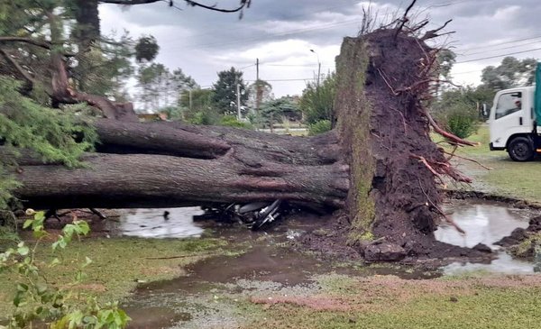
At around 4:20 p.m. this Tuesday, the weather station of the Uruguayan Institute of Meteorology (Inumet) in Soriano reported unusual gusts of wind: the measurement reached from 119 to 122 kilometers per hour, at its maximum peak. Those who were in the departmental capital recorded the event with their cell phones, and shared it on social networks.
They published photos and videos, accompanied by texts such as “tornado in Mercedes” or “turbonada”. By then, the worst was over, but the damage to the city was significant. Then, the media began to report what happened, and it was ruled out that it was a tornado. For the tranquility of its inhabitants, it had not been the same phenomenon of April 15, 2016 in Dolores.
Néstor Santayana, head of forecasts at Inumet, explained that same afternoon to The Observer that it was a wet downdraft. Two days later, the weather agency publishes a report detailed about what happened 48 hours earlier in Mercedes. Among them, explain the difference between a “microdowner and a tornado”. And it states that the descending ones can be wet or dry, depending on whether the precipitation associated with the original cloud of the phenomenon reaches the ground or not.
“Sometimes these downdrafts can be confused with tornadoes, due to their destructive effects. To distinguish, in case of doubt, the damage caused by a descending or blowout from that caused by a tornado; you have to observe the damage trace pattern”he adds.
“In the case of a descending tornado, it usually presents a linear or radial disposition with respect to a center (divergent), while tornado damage occurs in a corridor that the tornado leaves in its path, with objects knocked down on both sides (convergent). ), forming angles with each other, due to the curvature of the flow”, he indicates.
It was what happened between 4:20 p.m. and 4:35 p.m.. Worse still: it came accompanied by 36.4 millimeters of rainfall, in that period. That generated, flooded streets and that the drains could not cope. The maximum peak it was of 17.4 millimeters in 5 minutes. According to Inumet, “the reported damages are matching with the impact generated by gusts of wind and abundant precipitation associated with cells of strong and severe storms”.
The agency issued that morning of Tuesday 29 a “warning to the population” due to the probability of the occurrence of storms and heavy rains, which would be recorded from that same afternoon, due to the proximity of a cold front that would enter through the southwest of Uruguay.
From 3:15 p.m. to 7:15 p.m., the city of Mercedes was under orange weather alert for strong storms and heavy rainlowering its alert level to yellow starting at 7:15 p.m., and finally ceasing at 9:50 p.m.
It has a horizontal dimension of less than 10 kilometers, and can go from five to 30 minutes. When the horizontal dimension is less than four kilometers it is called a micro-downturn or micro-outburst. In the latter case they also tend to last less in time (no more than 15 minutes), states the Inumet, based on information from the Spanish State Meteorological Agency (Aemet).


