MADRID, Spain.- Tropical storm Ian became the first category 1 hurricane this Monday, reported the US National Hurricane Center (NHC).
Ian, the fourth hurricane of the current hurricane season, is moving at 22 kilometers per hour with maximum sustained winds of 120 kilometers per hour.
hurricane #Ian Advisory 13: Ian Becomes a Hurricane and Additional Rapid Strengthening Is Expected Today. Expected to Produce Significant Wind and Storm Surge Impacts In Western Cuba. https://t.co/tW4KeFW0gB
— National Hurricane Center (@NHC_Atlantic) September 26, 2022
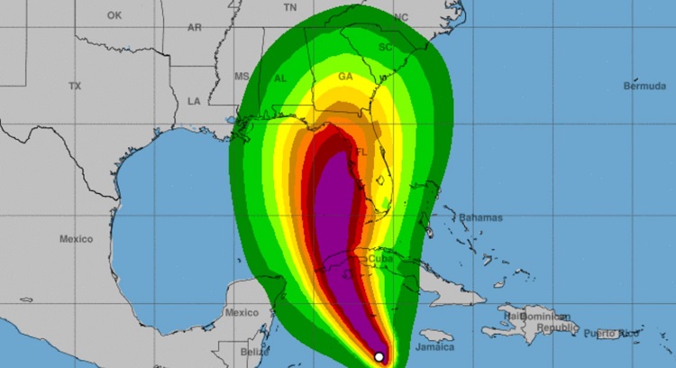
At five in the morning, its center was estimated at 18.2 degrees North latitude and 82.0 degrees West longitude, a position that places it 380 kilometers south-southeast of Carapachibey, Isla de la Juventud and about 515 kilometers southeast of Cape San Antonio, western end of Pinar del Río.
According to the predicted trajectory, The eye of the hurricane should pass this Monday morning near the Cayman Islands and between tonight and early Tuesday morning over western Cuba. It will then continue over the southeastern Gulf of Mexico, passing west of the Florida Keys on Tuesday night. While on Wednesday it should approach the west coast of Florida.
According to Indian According to the Cuban Institute of Meteorology (INSMET), from the end of this morning the clouds will increase in the west of the country, with rains that can be heavy in some localities, mainly on the Isle of Youth. The outermost circulation of Ian, in combination with the afternoon instability, can lead to numerous rains in the center of the country, during the afternoon and evening hours today.
As of the end of the afternoon, tidal waves will begin on the southwestern and central coast, which will be strong from the night to the south of Pinar del Río and Isla de la Juventud, with coastal flooding starting early Tuesday morning on the southwestern coast. .
The Cuban Government reported that they have begun the evacuation work in the face of Ian’s imminent threat.
In the province of Pinar del Río, classes were suspended until the Meteorological phenomenon does not represent a danger to life.
According to the guidelines of the Civil Defense of Cuba, “the inhabitants in the danger, risk and vulnerability zones” will be evacuated, as well as progress “in the dissemination of the measures to apply in the different phases (Alert, Alarm), in such a way that time is gained to speed up decision-making”.
Receive information from CubaNet on your cell phone through WhatsApp. Send us a message with the word “CUBA” on the phone +525545038831, You can also subscribe to our electronic newsletter by giving click here.
