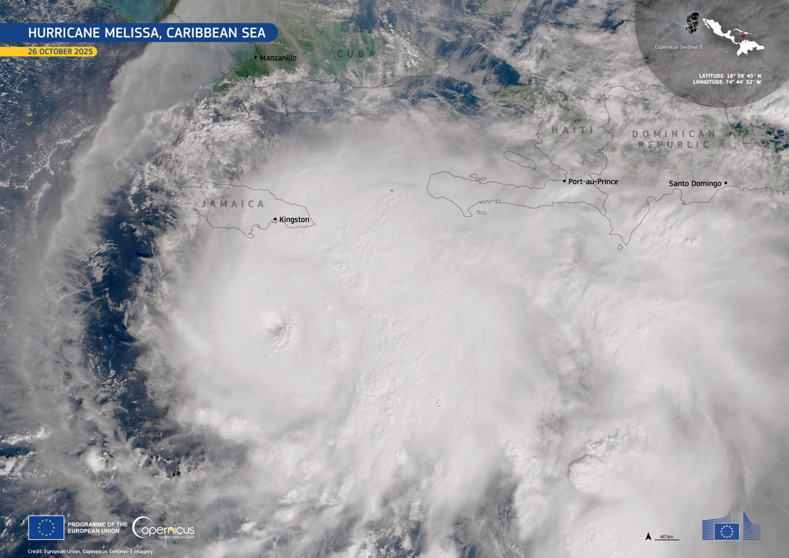
Hurricane Melissa reached the category 5 on the Saffir-Simpson scale, with maximum sustained winds of 270 km/h and more intense gusts, while it slowly advances towards the northern Caribbean, very close to Jamaica.
He National Hurricane Center (NHC) of the United States warned that conditions of “catastrophic” and “deadly” winds over Jamaica starting tonight and during the early hours of Tuesday.
According to the latest NHC report, the center of the hurricane was located near latitude 16.4 north and longitude 78.2 west, moving west at only 6 kilometers per hour.
The trajectory models indicate a gradual turn towards the northwest and north this Monday, and then tilt to the northeast between Tuesday and Wednesday, he said. Jamaica Observer.
This would place the eye of the hurricane over Jamaica in the next few hours and over southeastern Cuba on Tuesday night.
“Within the eye of the hurricane, a total structural collapse is likely, especially in elevated areas where wind speed can be up to 30% stronger,” the US agency warned.
#Melissa‘s winds are likely to destroy buildings, cause widespread damage, cut power & communications for days, and leave communities isolated in Jamaica.
Catastrophic flash flooding and numerous landslides are also likely, with storm surge and damaging waves on the south coast. pic.twitter.com/mfnjDS6hz2
—Zoom Earth (@zoom_earth) October 27, 2025
Preparations and evacuations in Jamaica
He Government of Jamaica declared maximum alert and activated its national emergency plan before what could be the most powerful hurricane to hit the island since 1988, when Hurricane Gilbert (category 3) left at least 40 dead and destroyed more than 100,000 homes.
“Heed the warnings. This is serious. It is a devastating storm,” urged Matthew Samuda, Minister of Water, Environment and Climate Change, in statements to cnn.
The official confirmed the provision of more than 800 shelters throughout the country and the deployment of Jamaica Defense Force teamsthe national bus service and the disaster management unit to support mass evacuations.
Samuda stressed that 70% of the population lives within five kilometers of the coast, where the greatest impact from storm surges and flash floods is expected.
“Without a doubt we are better prepared than in the 80s,” acknowledged the minister, “But we have never tested our infrastructure against winds of 260 kilometers per hour. “There is no system capable of resisting a force of that magnitude.”
An unprecedented phenomenon in the Western Caribbean
According to him Cuban meteorologist Henry Delgado ManzorMelissa constitutes “a new challenge” for the inhabitants of the eastern Cuba and Jamaica, regions that have never experienced the direct impact of a category 5 hurricane.
“Hurricane Melissa has become the third category 5 cyclone of the current season and could be among the most catastrophic in the history of the tropical Atlantic,” explained the expert.
Delgado Manzor recalled that in Cuba there is only a record of two hurricanes of that intensity: Cuba (1924) in Pinar del Río and the Irma (2017) in Camagüey.
“The call is clear: minimize risks, seek safe refuge and protect life. Prevention is the key,” insisted Delgado Manzor.
Critical trajectory towards the southeast of Cuba
If the current forecast holds, The core of Melissa will move over Jamaica between Monday night and early Tuesday morning, impacting the southeast of Cuba during Tuesday night and early Wednesday morning.
It would then continue towards the Bahamas on Thursday, although still with great intensity.
The Cuban authorities have activated their surveillance and preparation mechanisms in the provinces of Granma, Santiago de Cuba, Guantánamo and Holguín, in coordination with the Civil Defense, given the possible direct influence of the phenomenon.
Meanwhile, in Jamaica, meteorologists insist: “There is no time to lose. Melissa represents a “unprecedented threat to the island.”
