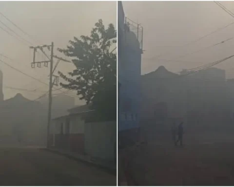
MADRID, Spain.- Since Monday night, the western region of Cuba has been affected by heavy rains and winds due to the incidence of Hurricane Ian, which He touched ground on the Island at 4:30 am this Tuesday.
Users of social networks and official media have shared images of the effects that Ian leaves in his wake.

The strongest wind gust recorded so far was 208 kilometers per hour in San Juan and Martínez.

The winds and rainfall in different locations in Pinar del Río have caused damage to homes, tobacco houses and other facilities.

Hurricane Ian, which entered Cuba through La Coloma, Pinar del Río province, with winds of 205 kilometers per hour, had its center at 6 o’clock in the morning at 22.4 degrees North latitude and 83.7 degrees West longitude, position which placed it about 25 kilometers south of Viñales and 40 kilometers south of Puerto Esperanza, according to the Cuban Institute of Meteorology (INSMET).
At 7:30 it was 28 kilometers south of Puerto Esperanza.
In La Coloma, the sea level has risen considerably and has penetrated the houses quickly and intensely.
Hurricane #Ian located by our meteorological radars 28 kilometers south of Puerto Esperanza, province of #Pinewood of the river at 7:30 a.m. pic.twitter.com/D5IY7RAzGe
— Forecast Center, Insmet (@cnp_insmet_cuba) September 27, 2022
According to forecasts, the center of the hurricane will leave the Island in the next few hours through Puerto Esperanza, to continue over the southeast of the Gulf of Mexico, and west of the Florida Keys, on Thursday.

Specialists point out that the hurricane will reach category 4 on the Saffir-Simpson scale, out of a total of 5.
Receive information from CubaNet on your cell phone through WhatsApp. Send us a message with the word “CUBA” on the phone +525545038831, You can also subscribe to our electronic newsletter by giving click here.