They say that five centuries before the Christian era, the Greek engineers Kleoxenos and Demokleitos devised a communication system that only worked at night. They placed torches on two roads separated by a hill and, depending on how many were lit and their order, the message could be deciphered one way or another by the locals. Hundreds of tribes used the blazing fire to scare off predators and, at the same time, alert other communities that a settlement was there. until Thomas Edison made a light bulb shine and, since then, light has been synonymous with a house in which people live, a city or a huge skyscraper.
Uruguay also continues to light up and the “becoming light” continues to be one of the best predictors of the populations that settle down. The growth in the supply of electricity services between June 2021 and June 2022 – read the number of new connections to the grid – show that things are happening in the slightly undulating peneplain and that not everything is happening in the capital. This is confirmed by the information prepared by the public energy distribution company (UTE) at the request of The Observer.
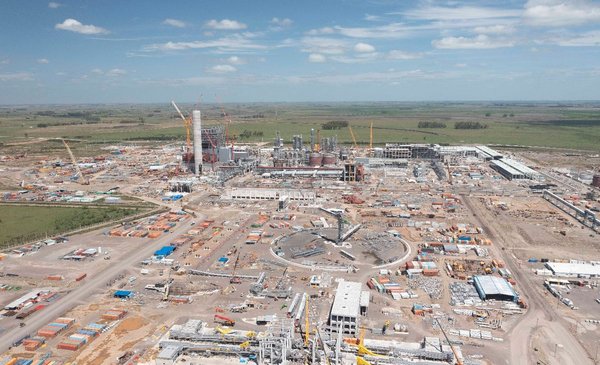
Because in the heart of the Uruguayan map, where darkness once reigned every time Google satellites took night images, the installation of the UPM 2 pulp mill is marking a new colonization. Not only did the electrical power allocated to the area increase –for the normal operation of the plant–, but it The Blanquillo commercial service center – where Pueblo Centenario depends – increased the number of customers (of new supplies) by 5%. It went from 704 to 741 in one year.
joint venture
Growth of energy supplies between June 2021 and June 2022.
This trend is also observed in the nearby offices of San Gregorio del Polanco or Santa Clara, with increases in supply close to 4% in one year. Because in the limits of Tacuarembó and Durazno “there is an axis of attraction” associated with the opportunities offered by the UPM facility, explains the architect Alicia Artigas, consultant in land use planning. But this “cyclical” phenomenon, she says, does not change the macro photo: in Uruguay more than nine out of ten live in a housing estate and the concentration of population is on the southern coast of the country and on the coast against the Uruguay River.
The satellite images are, in this sense, eloquent: although there are little-explored areas that light up (such as Pueblo Centenario, La Coronilla or La Barra de Punta del Este linked to the Argentine boom), the metropolitan area gets all the attention in which appears to be an orange (illuminated) blob on an almost black background. Something similar is observed when the satellite rests on the two Koreas and the dissimilarity between the south and the north, or between the east coast of the United States and its center-west area can be contemplated.
The growth of electricity supplies –as a symptom of population movement– is also observed in the metropolitan area, but due to a different phenomenon. While the area with the greatest services empties (it can be seen in the most central neighborhoods of Montevideo), there is an extension towards the coast of Canelones and the western route that leaves for San José.
“The growth of the peripherals is given by high-income sectors that settle on the coast, in complexes more of a style countryand by the growth of vulnerable peripheries in irregular settlements or cheaper formal housing”, explains the architect.
And this expansion has its cost. The United Nations Population Fund had estimated that the emergence of irregular settlements in areas where there are no services costs the State an extra cost of between 50% and 100% compared to if it had been planned the settlement and only later settled in the community.
While the inhabitants of municipality B of Montevideo find, on average, a high school four blocks from their home, those of municipality G have to walk 15. An average Montevidean has a polyclinic or health service (even if he is not a member) seven blocks.
Those in the most central area have the service five blocks away, those in the periphery more than 12. This was confirmed by a study led by the architect Gonzalo Bustillo of the Faculty of Architecture of the University of the Republic.
This scenario is aggravated if the borders of Montevideo are crossed towards Canelones. UTE reported a 5% growth in electricity supplies in the Toledo area. But there is also a 4% expansion in Progreso or La Paz.
South Miami
The ads feature newly built houses, freshly cut green grass, the glare of the sun on the lake and messages that allude to a life outside the bustle of the city. In Paso Carrasco and the vicinity of the Carrasco airport, the new Miami of the South has been growing.
But like Miami, which was built on swamps, Paso Carrasco and its surroundings are flood prone areas. According to the Ministry of the Environment, more than 3,000 people live there in parts with a “very high” risk of being under water..
The architect Artigas says that the tax benefits caused a real estate offer in that area that, in general, is not accompanied by a demand.
Passing that Miami, after the Pando toll, another phenomenon flourished: alternative communities, Montevideans seeking contact with nature (more in times of health emergency) and irregular settlements with occupation of old subdivisions. The result? Primary found that, unlike what happens in the rest of the country, there lacked free benches in schools.
“It is estimated about 500,000 dollars per hectare of services”, so the arrival of the same would be transferred to the value of the land. But, for Artigas, there is something more serious: while productive lands are occupied (with the environmental impact that this entails), the areas where the services are already located remain empty. The empty houses in Montevideo, for example, would provide accommodation for all the people from the irregular settlements in the capital.


