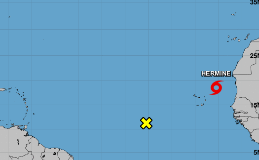
Miami (EFE).- Tropical storm Hermine, the eighth of the current cyclonic season in the Atlantic, formed this Friday northeast of the African islands of Cape Verde, with a forecast of heavy rains for the Canary Islands (Spain), while other systems keep Canada and the center of the Caribbean Sea on alert.
At 9:00 p.m. GMT, the center of Hermine was 290 miles (470 km) northeast of Cape Verde, with maximum sustained winds of 40 miles per hour (65 km / h), according to the latest bulletin from the National Hurricane Center ( NHC) American.
Although there are no coastal watches or advisories in effect at this time, Hermine is forecast to produce 2 to 4 inches (50 to 100 mm) of rain, with isolated totals of 6 inches (150 mm), over the Canary Islands through this end of week.
Some strengthening is possible tomorrow, with weakening expected on Sunday, and Hermine could become a remnant low on Monday, the observatory forecasts.
It was planned that the name of Hermine would receive the tropical depression 9 that is located in the Caribbean, so if it becomes a storm in the next few hours, it will be called Ian.
Depression number 9 strengthens in its advance towards the center of the Caribbean, from which it can make the jump to Florida as a major hurricane after passing through Jamaica and Cuba over the weekend, while the force of Hurricane Fiona will be felt this Friday in eastern Canada.
The NHC informs in its last part that Nueve is located 515 miles (830 km) east of the capital of Jamaica, Kingston, and 1,015 miles (1,635 km) from Havana and advances with maximum sustained winds of 35 miles per hour (55 km/h).
Although it is still early to know the exact magnitude of the cyclone, some forecasts indicate that it could pass through Cuba as a category 1 or 2 hurricane and even reach the coast of Florida (USA) as a 3.
The NHC stresses that Jamaica and the Cayman Islands must closely monitor the progress of this system, which is moving west-northwest at 14 miles per hour (22 km/h).
The system is expected to make a westward turn today and continue through Saturday, followed by a northwesterly orientation Sunday and Monday.
On the track, the cyclone is forecast to move through the central Caribbean through Saturday, pass south of Jamaica on Saturday night and Sunday, and approach the Cayman Islands on Sunday night and early Monday. .
Monday night could reach Florida.
The still tropical depression 9 is expected to produce rains in Aruba, Bonaire, Curaçao, northern Venezuela and northern Colombia, and more intense in Jamaica, the Cayman Islands and Cuba.
Hurricane Fiona, the third this season, is about 475 miles (770 km) from Halifax, the capital of the province of Nova Scotia (Canada), and has maximum sustained winds of 130 miles per hour (215 km / h). .
The Bermuda Weather Service has already suspended the tropical storm warning for the Atlantic archipelago.
A hurricane watch is in effect in Canada for Nova Scotia from Hubbards to Brule, Prince Edward Island, Isle-de-la-Madeleine, and in Newfoundland from Parson’s Pond to Francois.
Fiona is moving northeast near 35 miles per hour (56 km/h) and on the forecast track, the center of the cyclone will approach Nova Scotia today.
On the other hand, tropical storm Gastón, which is moving towards the Azores, is located 130 kilometers from the island of Faial, in the center of that Atlantic archipelago, with maximum sustained winds of 65 miles per hour (100 km / h). .
A tropical storm warning is in effect for the islands of Flores and Corvo in western Azores, as well as Faial, Pico, Sao Jorge, Graciosa and Terceira.


