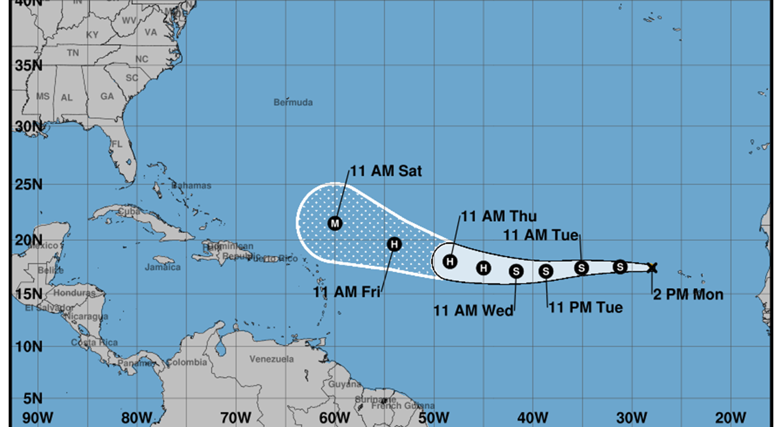
The area of low pressures that formed in the Eastern Atlantic continued to organize during the early morning and the morning of this Monday, until it became the fifth tropical storm of the season, called Erin.
According to him Forecasting Center of the Institute of Meteorologyat 11:00 am its center was located at 17.4 degrees of north latitude and 28.0 degrees of west longitude, about 455 kilometers west-northwest of the Islands of Cape Verde and 3710 kilometers east of the northern group of the minor Antilles.
Erin presents maximum sustained winds of 75 kilometers per hour, with upper gustsand a central pressure of 1004 hectopascales.
It moves west at a speed of 31 kilometers per hour.
11am edt mon a Aug 11th – Tropical Storm #Erin You have formed in the Far Eastern Tropical Atlantic Just West of the Cabo Verde Islands.
MAXIMUM SUBSTAED WINDS ARE 45 MPH & INTENTITION IS FORECAST AS IT MOVES WESTWARD ACROSS THE OPEN TROPICAL ATLANTIC.https://t.co/tw4kege9uj pic.twitter.com/jutkjpe8is
– National Hurricane Center (@NHC_Atlantic) August 11, 2025
The projections indicate that the system will maintain a similar direction and speed, gradually gaining in organization and intensity as it advances on open waters of the eastern Atlantic, the Insmet.
At the moment, tropical storm Erin does not represent a danger to Cubaalthough, due to their position and the time of the year, specialists maintain close surveillance about their evolution.
The next official part will be broadcast at 6:00 pm on Monday.


