April 11, 2023, 3:38 PM
April 11, 2023, 3:38 PM
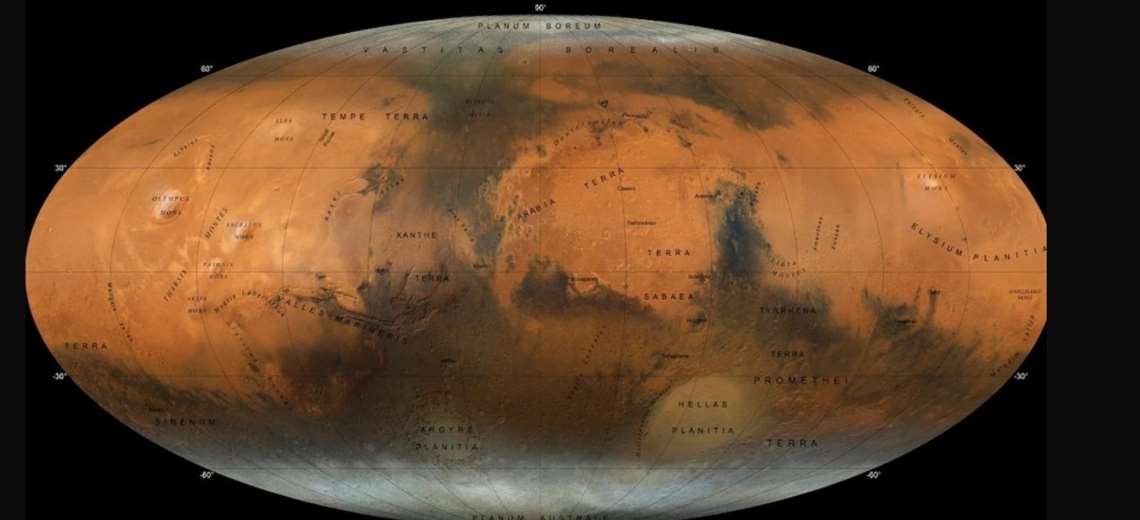
The New York University Abu Dhabi (NYUAD) has created a new atlas of Mars, with a higher level of detail than the previous ones, thanks to the images taken by the Emirati Hope probe, which has been orbiting the red planet since February 2021, and whose technology will allow us to understand Martian weather phenomena.
The mission of the United Arab Emirates has indicated today on Twitter that this new map was produced with photographs taken by the Emirates Exploration Imager (EXI), a state-of-the-art instrument installed on the Hope probe capable of taking high-resolution images to study the Martian atmosphere.
For the creation of this full-color global map, “more than 3,000 observations” from EXI were brought together, which were combined with the ArcMap tool to obtain a “global image” of the planet.
Using these data, NYUAD has created “a never-before-seen map of Mars,” according to a university statement, which notes that the new map shows regions and features of the red planet in “exceptional resolution.”
Thanks to these new images, the polar caps, mountains, volcanoes, remains of ancient rivers, lakes, valleys and impact craters that make up the orography of Mars can now be observed in great detail.
This will allow scientists to “learn about the momentous changes in the climate that can fundamentally alter the planets,” information that may also be useful for a greater understanding of our planet Earth, according to the statement.
The Emirates mission to Mars It is the first interplanetary mission for the country and the Arab world, and the Hope probe completes an orbit of the red planet every 55 hours to capture a full sample of planetary data and every nine days to “map the atmospheric dynamics” of this planet.
Edited by Enrique López with information from efe and the University of New York in Abu Dhabi


