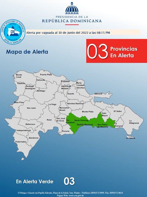
Until this morning, the Emergency Operations Center (COE) maintained three provinces on green alert for possible flooding of rivers, streams and ravines, as well as sudden floods due to the incidence of a trough located northeast of Puerto Rico that is combined with the effects generated by the east/northeast wind.
indicated the COE that the demarcations under alert are Greater Santo Domingo, San Pedro de Macorís and San Cristóbal, while the National Meteorological Office (Onamet), explained that the humidity over the Dominican Republic will decrease slowly.
He pointed out, however, that the lagging humidity plus the trade wind and a trough that brings instability will be responsible near noon and until hours of the night for producing cloudy increases, locally moderate downpours, thunderstorms and gusts of wind in communities of the Regions: North, Northeast, Caribbean Coastal Plain (Greater Santo Domingo) and the Cordillera Central.
In addition, he specified that he is monitoring a potential category 2 tropical cyclone, which is located 475 kilometers east of Bluefield, Nicaragua, with maximum sustained winds of 65 kilometers per hour and moves west at 30 kilometers per hour, which due to its position and displacement offers no danger to the Dominican Republic.
You may be interested in reading: Onamet: trough will continue to cause rain at least until Saturday
In this sense, ONAMET monitors the development and displacement of an active tropical wave located hundreds of kilometers east of the Lesser Antilles, with a low probability of 10 percent, to become a tropical cyclone in the next two days.
In another order, it also reported another disorganized area of showers and thunderstorms to the west of the Gulf of Mexico, with a low probability of becoming a tropical cyclone.


