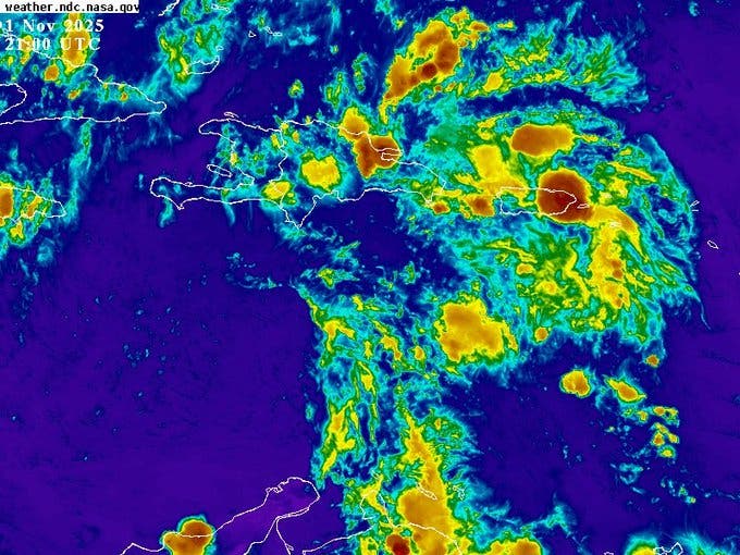
Santo Domingo. — An active tropical wave is moving rapidly westward, approaching Dominican territory, and its interaction with a trough located at different levels of the troposphere maintains high levels of humidity and instability over much of the country.
According to the Dominican Institute of Meteorology (Indomet) as a consequence, they are expected moderate to heavy showersaccompanied by thunderstorms and gusts of windmainly in the Caribbean coastal coastlineas well as in the regions northeast, southeast, Cibao valley, Central mountain range and border area.
Among the provinces most likely to be affected are: La Altagracia, La Romana, San Pedro de Macorís, El Gran Santo Domingo, San Cristóbal, Hato Mayor, El Seibo, Monte Plata, Peravia, San José de Ocoa, Azua, Sánchez Ramírez, Monseñor Nouel, María Trinidad Sánchez, Samaná, Duarte, La Vega, Santiago, Santiago Rodríguez, Dajabón, Valverde, Puerto Plata, Monte Cristi, Independencia, Bahoruco and Elías Piñaamong others nearby.
You can read: COE increases provinces on yellow alert due to tropical wave
By Sunday, the tropical wave will be located over the country and, combined with the trough, will continue to generate moderate to heavy showers, thunderstorms and gusts of wind, especially during the afternoon.
The most affected provinces are expected to be: La Altagracia, Monte Plata, El Seibo, Hato Mayor, La Romana, San Pedro de Macorís, Santo Domingo, San Cristóbal, Azua, Barahona, Pedernales, La Vega, Santiago, Dajabón, Santiago Rodríguez, Independencia, Elías Piña and San Juan. It is predicted a decrease in rain during the early hours of the night.
The meteorological and civil protection authorities have issued warnings and alerts for possible floodsespecially in low areas and communities near rivers and ravines. It is recommended to the population take precautionsavoid traveling through flood-prone areas and stay informed about the evolution of the phenomenon.


