He National Meteorological Service (SMN) anticipate a contrast weekend in the country: heavy rains In the south and southeast, showers in the center and the West, and extreme heat in the north and the Yucatan Peninsula.
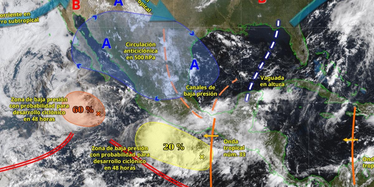
The interaction of the tropical wave number 33, a low pressure zone with cyclonic potential and the Mexican monsoon will be the combination that will maintain the instability in much of the territory.
Rains and thunderstorms
From Friday afternoon until Sunday, they are expected Very strong rains A intense punctual in Oaxaca, Chiapas, Tabasco, Veracruz and Guerrero, with a probability of electric shocks, hail fall and risk of flooding and increase in the levels of rivers and streams.
In the west and center of the country – including Jalisco, Michoacán, State of Mexico and Mexico City – showers and heavy rains are expected, while in the Yucatan Peninsula there will be rainfall to strong to strong, especially on Sunday, when a new tropical wave moves over the region.
Winds and elevated waves
The coasts of the South Pacific, from Guerrero to Chiapas, will have wind gusts up to 70 km/hy elevated waves, which could reach 2.5 to 3.5 meters high on Sunday. In Baja California Sur and the northwest of the country, the Mexican monsoon will maintain the presence of rains, winds of up to 50 km/hy wave of 1.5 to 2.5 meters.
Extreme temperatures
He hot atmosphere It will continue in the north and southeast. Baja California, Sonora, Chihuahua, Sinaloa, Jalisco, Colima, Michoacán, Campeche, Yucatán and Quintana Roo will register maximum temperatures of 35 to 40 ° C, while in mountainous areas of the State of Mexico, Tlaxcala and Puebla, the morning will be cold, with minimum of 0 to 5 ° C.
Recommendations for the weekend
Authorities recommend extreme precautions to possible landslides, floods and flooding, as well as avoid crossing rivers or streams. In coastal areas, caution is suggested by elevated waves and attend to civil protection notices.


