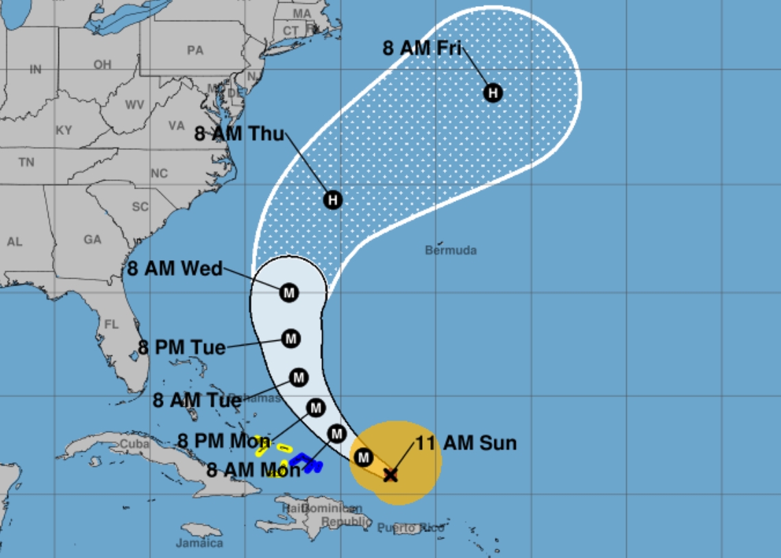
Hurricane Erin, First to train at the Atlantic Ocean in this Cyclonic seasonits progress continues as a storm of great intensity to the north of Puerto Rico and the Dominican Republic, although its course will progressively move it away from Cuba.
After becoming a hurricane last Friday, Erin reached category five yesterday to become one of the phenomena of his fastest intensification in history. In just over 24 hours he had reached the highest category on the Saffir-Simpson scale.
This rapid intensification placed it as one of the hurricanes of greatest registered strengthening, and possibly as the fastest growing tropical cyclone on dates prior to September 1, according to CNN.
This is a phenomenon that has been observed more regularly in recent years as a result of global warming.
At 11:00 am this Sunday (local time), Erin was 320 kilometers (km) northwest From San Juan, in Puerto Rico, already 385 km east of the Gran Turk Island, in Turks and Caicos, according to The National Hurricane Center (NHC) of the United States.
After reaching category 5, Erin has reduced its intensity to category 3 and moves to the west-northwest near a speed of 20 km/h.
It has maximum sustained winds of 205 km/h, with upper bursts, which extend by 35 km from its center, while the winds with tropical storm cover up to 335 km out. Its central pressure is 946 Hectopascal.
According to weather forecasts, your movement is expected to decrease speed and take a gradual turn to the north between Monday and Tuesday.
The intense rainy areas will hit the Virgin and Puerto Rico Islands on Sunday with accumulated that could reach between 76 and 152 millimeters.
During his career the Erin core must go east of the Turkish islands and Caicos and the southeast of the Bahamas tonight and Monday, where tropical storm conditions are forecast.
However, it is not forecast to have direct impact on land.
Erin must also produce strong swells that will affect the Virgin Islands, Puerto Rico, La Española, Turkish Islands and Caicos during the next few days. During the week the intense waves will arrive in the Bahamas, Las Bermudas, the east coast of the United States and the Atlantic of Canada.
It is forecast that its intensity continues to suffer fluctuations in the next 24 to 48 hoursbut experts expect it to remain a dangerous older hurricane until the mid -week.


