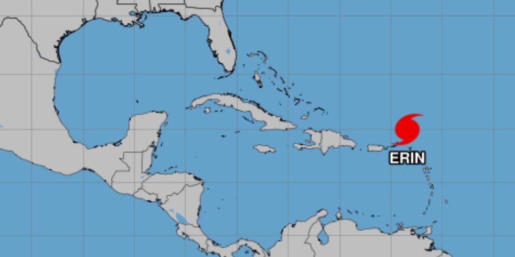
Currently the system is 170 km north of Anguila, with maximum sustained winds near 255 km/h.
Arequipa, Peru – the American National Hurricanes Center (NHC) reported this Saturday that Hurricane Erin, first of the 2025 season in the Atlantic, reached category five in the waters of the Caribbean Sea.
The NHC had already predicted the strengthening of this system during the current weekend and the course of the following days. The system is currently 105 miles (170 km) north of Anguilla, with maximum sustained winds close to 160 mph (255 km/h).
Erin is expected to cause dizzy this Saturday and Sunday that will affect northern parts of the Sotavento Islands, the Virgin Islands, Puerto Rico, La Española and the Turkish Islands and Caicos.
Around the beginning of the following week, the swells will extend to the Bahamas, the Bermuda and the east coast of the United States.
INVESTMENT MANAGER ILS TWELVE Securis, cited by the agency Reutershe estimated that Erin remains far enough from the coast to avoid significant impacts on the east coast of the United States.
The hurricane moves at a rate of 16 mph (approximately 26 km/h) and its possible trajectory could deteriorate Climate conditions Also in Cuba, especially in the central-organic portion of the island.

The system is expected to pass north of the Sotavento Islands in northern the Caribbean before turning north between the east coast of the United States and Bermuda around Monday.
In addition, Erin is likely to produce areas of heavy rains until Sunday in the north of the Sotavento Islands, the Virgin Islands and Puerto Rico.
Cuba in the middle of the cyclonic season
Although Erin does not imply so far a real danger to the island, the current cyclonic season does not predict a particularly hopeful destination for the country.
Specialists from the centers of forecasts and the weather and the Institute of Meteorology in Cuba confirmed that the danger that the island is affected by at least one hurricane, during the cyclonic season that began on June 1 and will run until next November 30.
A state report Cuban News Agency He points out that for this 2025, the oceanic and atmospheric conditions of the Atlantic Ocean, the Gulf of Mexico and the Caribbean Sea, will be favorable so that the cyclonic season is active.
In this regard, experts considered in their estimates the formation of 15 tropical storms, of which eight could reach the hurricane category.
In relation to the origin of the weather phenomena, the specialists specified that of the total number of tropical cyclones expected with name, 10 would originate in the Atlantic Ocean, three in the Caribbean Sea and two in the Gulf of Mexico.
As they added, the chances of originating and intensifying at least one hurricane in the Caribbean is high (75 %), while it is 50 % for one of Atlantic origin to penetrate the Caribbean Sea.


