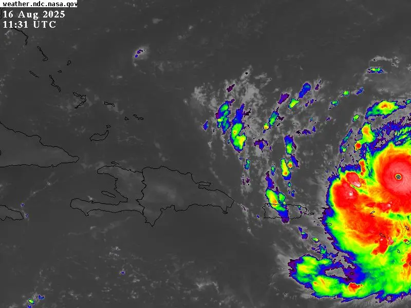
Downpours, thunderstorms and wind bursts will sometimes occur today in ten provinces as a result of The bands of clouds that emerge from Hurricane Erín and arrive in the country reported the Dominican Institute of Meteorology (INDOMET).
The demarcations with the greatest possibilities of rains are Altagracia, Hato Mayor, La Romana, El Seibo, San Pedro de Macorís, Monte Plata, Samaná, Sánchez Ramírez, Duarte and María Trinidad Sánchez.
In Santo Domingo and the National District El Cielo will sometimes be cloudy with downpours and thunderstorms.
Hurricane Erín Category 4 on the Saffir-Simpson scale, has maximum winds of 195 km/h, was located today 275 km northeast of Anguilla Island, minor Antilles, and moves west/northwest at a translation speed of 31 km/h, Indometin said in today’s bulletin.
In the sea, on the Coast of the Atlantic Ocean, due to the indirect effects of Hurricane Erín from Cabo hoax (La Altagracia) to Monte Cristi and on the Coast of the Caribbean Sea from Isla Saona, La Romana to Cabo deception, Altagracia is recommended to operators of all vessel Marino.
The rest of the Caribbean coast can navigate with due caution.
Indomet reported as the hurricane continues to move west/northwest to the northeast of the country in the Atlantic Ocean will continue avocado in the afternoon and night in San Cristóbal, San José de Ocoa, La Vega, Monsignor Nouel, Santiago, Mirabal Sisters, Puerto Plata, Monte Cristi, Dajabon, Elías, Piña, Santiago, Santiago, Santiago Rodríguez, Santiago, Santiago, Santiago, San Juan.
While the Emergency Operations Center (COE) issued green alert for the provinces of Altagracia, El Seibo, Samaná, María Trinidad Sánchez, Puerto Plata, Hato Mayor, Espaillat and Montecristi for abnormal waves and downpours in the area.
Meteorology reported that tomorrow the hurricane Erín will be closer to the country, but maintaining its center at a distance greater than 300 kilometers from the Dominican Republic and its outer cloudy bands will be downloading strong downpours, electric storms and frequent wind bursts in the Altagracia, Hato Mayor, La Romana, El Seibo, San Pedro de Macorís, Monte Plata, Samaná, Samaná, Samaná, Saman, Saman Duarte, María Trinidad Sánchez, San Cristóbal.
Also in San José de Ocoa, La Vega, Monsignor Nouel, Santiago, Mirabal Sisters, Puerto Plata, Peravia, Azua, San Juan, Barahona, Bahoruco, Independencia and Pedernales, and the Great Santo Domingo.
These rain conditions will be present until night, tending to gradually decrease during the early hours of Monday, while this system begins to move away from the country.


