Researchers from Brazilian universities and study centers developed a methodology for mapping the risks of natural disasters with the participation of residents, mainly students, to prevent the effects of floods, inundations, landslides and heavy rains.
The study, published in the magazine Disaster Prevention and Managementwas conducted by researchers from the National Center for Monitoring and Alerts for Natural Disasters (Cemaden), the Universidade Estadual Paulista (Unesp), the National Institute for Space Research (Inpe), the Federal University of Rio de Janeiro (UFRJ), and the University of Vale do Paraíba (Univap).
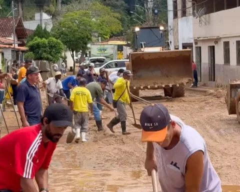
To develop the mapping methodology, the researchers had the participation of 22 students enrolled between 2019 and 2021 at the Monsenhor Ignácio Gioia state school, in the municipality of São Luiz do Paraitinga (SP). The city was partially destroyed by a flood in 2010, when the level of the Paraitinga River rose and left most of the population homeless.
The study used risk data, available on the internet, from the Geological Service of Brazil – Companhia de Pesquisa de Recursos Minerais (CPRM), a public company, linked to the Ministry of Mines and Energy – and images obtained with drones. With this information, together with the students living in the city, they prepared a map of risk and escape routes.
“Students identified on the map and were also developing escape routes so that people, within these floodable areas, would be the safe places that they could temporarily take shelter in the face of floods of five meters, ten meters, and so on. It is a planning exercise, a contingency plan made together with the people who live in the region”, highlighted sociologist Victor Marchezini, a researcher at Cemaden and supervisor of the work.
“If there is not this kind of involvement with the local people, responses to disasters end up being improvised, people are not prepared. We use São Luiz do Paraitinga as a living laboratory, thinking about prevention actions”, said the researcher.
During the research, students suggested, as a way to improve disaster prevention, the realization of territorial planning to avoid constructions in risk areas, and the creation of an application to quickly communicate response actions aimed at residents.
“It is always important that we have these plans, carry out the training together with the residents. But beyond that, we have to prepare ourselves for what is unthinkable, it is precisely when the extreme event is different from what we were used to”, highlighted Marchezini.
The research, whose first author is researcher Miguel Angel Trejo-Rangel, from Inpe, was supported by the São Paulo Research Support Foundation (Fapesp).