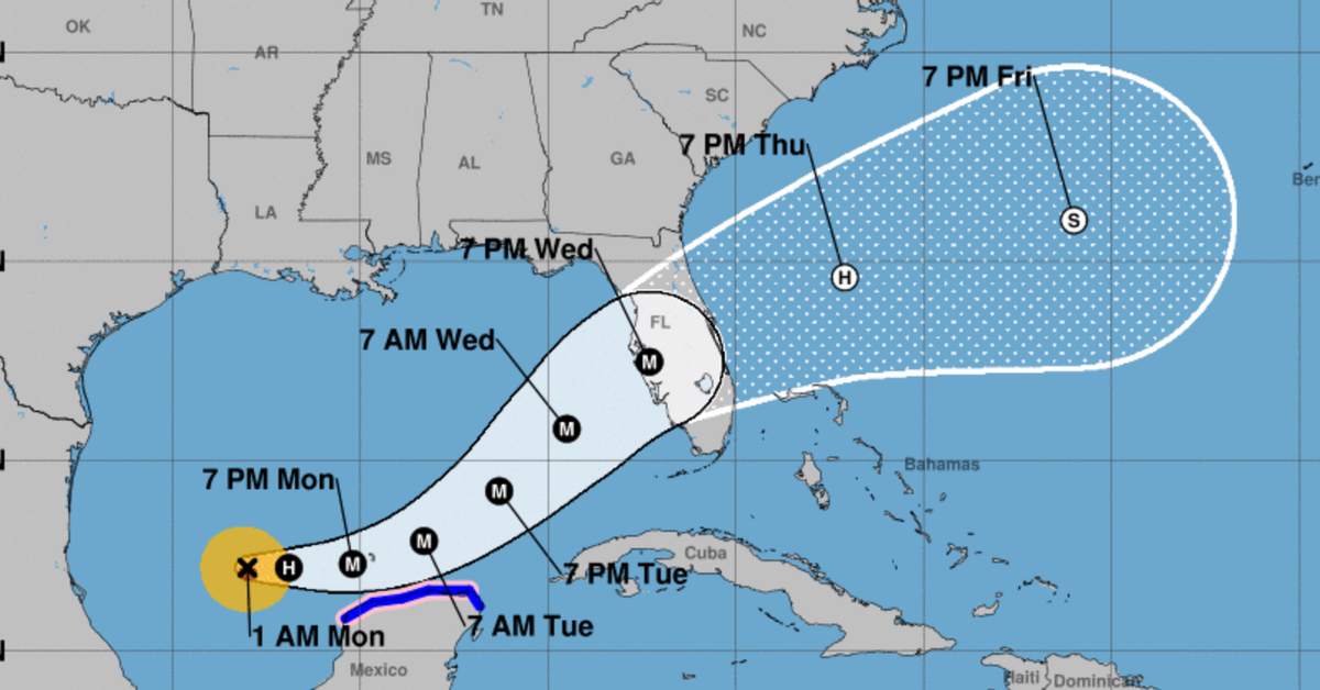
Havana/The forecast center of the Institute of Meteorology (Insmet) of Cuba indicated this Sunday that it is observing with “close surveillance” the evolution of Hurricane Milton – the ninth of the current tropical cyclone season – which is now moving through the Gulf of Mexico towards Florida.
At the end of September, Cuba received the indirect effects of Hurricane Helene during its close passage through the seas south of the western region of the Island, where its intense rains caused flooding in coastal towns, electricity outages, damage to agriculture and other havoc.
“In the next 12 to 24 hours this system will move slowly with a course between the east and the east-southeast, slightly increasing its translation speed,” indicated the most recent cyclone warning from Insmet.
“In the next 12 to 24 hours this system will move slowly with a course between the east and the east-southeast, slightly increasing its translational speed”
He also warned that in this period Milton – currently a category 1 cyclone on the Saffir-Simpson scale of a maximum of 5 – will continue to gain in “organization and intensity” so it may become a “high intensity” hurricane this Monday.
The Cuban meteorological institution points out that due to the current position and future trajectory of this hurricane – northeast through the Gulf of Mexico – on its way towards the Florida peninsula in the next 48 to 72 hours, it will maintain “close monitoring of its evolution.” over the next few days.”
For this Monday, according to the most recent report, from 3 am, cloudy weather will predominate in the west and center and it will be partially cloudy in the east, with isolated showers and rains in Pinar del Río and Isla de la Juventud, which since the first hours of In the afternoon they will extend to the north, west and center to the province of Holguín.
In the rest, the rains will be more isolated. In the afternoon, maximum temperatures will be between 32 and 35 degrees Celsius, higher in localities in the eastern interior. At night temperatures will drop and reach values between 24 and 27 degrees Celsius.
The winds will be weak variables, from the end of the morning they will blow between the south and southwest in the west, with speeds between 15 and 30 kilometers per hour, with higher gusts in the western end. There will be little waves on the northern west and east coasts, with calm seas on the rest of the coasts. From the morning the waves will increase to little to the south of the western end and Isla de la Juventud.
Forecasts for the current 2024 hurricane season in the North Atlantic, the Caribbean Sea and the Gulf of Mexico, valid from June 1 to November 30, indicate that it will be “very active” with the possible formation of 20 tropical storms.
According to statistics from Cuban meteorologists on October tropical cyclones from 1851 to date, in this period 44 of these organisms hit Cuba with the category of hurricane, and 29 of them impacted the provinces of its western region.
Of the hurricanes that hit the Island in October, 17 turned out to be of great intensity
Likewise, they report that of the hurricanes that have hit the Island in October, 17 turned out to be of great intensity (categories 3, 4 or 5 Saffir Simpson), and that is why in Cuba the tenth month of the year is recognized as “the month of the cyclones”.
Last year, Cuban experts predicted a “moderate” season that finally exceeded expectations with 17 tropical storms recorded, six of which became hurricanes.
The last time a major hurricane hit Cuba was in September 2017 when Irma moved parallel to the northern coast of the Island and caused ten deaths and material losses officially valued at $13.185 million.


