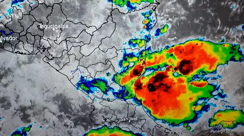
The Nicaraguan Institute of Territorial Studies (Ineter) reported that heavy rains and electrical storms are expected in Nicaragua due to the arrival of tropical wave number 14. According to the climate report, this natural phenomenon is expected to enter the national territory on the afternoon of Monday, July 17, or in the early hours of Tuesday, July 18.
In this sense, the institution is monitoring the flow of the Escondido, Prinzapolka and Grande de Matagalpa rivers; since the abundant precipitations that have been registered in the last days have caused an increase in their levels.
Marcio Baca, director of Ineter Meteorology, explained that “it is likely that the tropical wave will arrive in the afternoon of Monday or at night on Tuesday. This will cause heavy rains and we are closely monitoring the levels of the Escondido, Prinzapolka and Grande de Matagalpa rivers, which have already experienced an increase in their flow due to the abundant rains of previous days. We are closely following the evolution of these rivers with the approaching tropical wave.”
Related news: Rain forecast for this week in Nicaragua
He also mentioned that with the arrival of the tropical wave, precipitation is expected in the Central and Pacific region of Nicaragua. Also, some low-intensity thunderstorms are likely.
Likewise, the expert predicted that after the passage of tropical wave number 14, a notable decrease in the amount of rain is expected, with the presence of precipitation for Wednesday, July 19, being very unlikely. “We will be counting on very good weather to celebrate our July 19,” he added.
The owner of Ineter also reported the entry of tropical wave number 15, which will cause rain between Thursday and Friday. This natural phenomenon will mainly affect the northern Caribbean area of the country, generating more precipitation, while isolated rains are expected in the rest of the territory.
«We refer to the North Caribbean. That is where it will be dropping most of the precipitation, while in the rest of the country some isolated and scattered rains are expected,” he said.
Although the seas are in normal conditions at the moment, the Internet has called on Caribbean fishermen to be vigilant. A considerable increase in the height of the waves, of more than 2 meters, is expected as the tropical wave number 14 crosses the area, tomorrow Tuesday.


