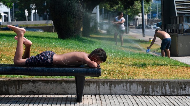
Despite the rains and the consequent drop in temperatures, much of the country is still under the rigors of a heat wave and more than half of the national territory endured temperatures above 30 degrees, according to the National Meteorological Service (SMN).
This is the case of CABA this Sunday recorded its fourth consecutive day of heat wave, while other latitudes accumulate “ten or eight days” under these conditions, the meteorologist and broadcaster of the SMN, Cindy Fernández, explained to Télam.
According to the ranking of body temperatures, At 2:00 p.m. this Sunday, temperatures above 30 degrees were recorded in 52 of the 80 active weather stations (65%).
At 5:00 p.m., the SMN data indicated that they were enduring intense heat Santiago del Estero with 44.4, Las Lomitas in Formosa 42.6, Termas de Río Hondo 42.3, Ceres in Santa Fe, and Chamical in La Rioja 42.2.

For its part, the City of Buenos Aires (CABA) registered 32.9 degrees and a thermal sensation of 37.9.
Meanwhile, at 9:00 p.m., Santiago del Estero maintained the highest record, with 39ºC, as well as San Fernando del Valle de Catamarca, while Salta indicated 36.8ºC, Resistencia, in Chaco 36.7ºC, Santa Fe 36.4ºC and Formosa 36ºC.
Meanwhile, the City of Buenos Aires marked 29.3°C at the same time, and the lowest temperatures were recorded in Río Gallegos and Río Grande, with 7ºC, and Ushuaia with 3.9ºC.
In turn, the SMN issued a yellow storm warning for the east of Córdoba, south of Santa Fe, almost the entire territory of Corrientes and the north of the province of Buenos Aires in the last update at 6:13 p.m.

At noon, much of the country remained “within heat wave values, with temperatures around 41 and 42 degrees” despite the rains recorded in the center of the country and the entry of cold air into the atmosphere.
“The cold air is going to move north gradually, but the north has one or two more days with high temperatures, starting Tuesday they will experience a drop that will not last long because the heat has not ended,” he added. .
“There are some places in the country, such as the Cuyo area, that have had a heat wave between 8 and 10 days, while the north of La Pampa has had 7 days, Córdoba between 5 and 7, and the province of Buenos Aires, between 3. and 5 days”, he said regarding this meteorological phenomenon that ranges from the center of Patagonia to the north of Argentina.

Next days
For the days to come, more rains and a drop in temperatures to levels below the average for the time of year in CABA and surroundings are expected, which will normalize towards the weekend.
“From the end of the afternoon and the beginning of the night, a decrease in thermal marks will begin to occur and until Wednesday we will have low temperatures for the summer, with maximums below 25 degrees and minimums of 20 degrees,” said Fernández. .
Temperatures will rise from Wednesday and the heat is expected to return towards the weekend.
rains
As for the rains, the accumulation for the City of Buenos Aires and its surroundings since last night is 55 millimeters, but “new storms will be arriving in the afternoon/night/early morning” and in the coming days “we will continue to have storms” in the framework of a week “characterized by much more cloudiness, instability and the occurrence of intermittent showers.”
“Now we are with an east wind, air with a lower temperature and humidity, but coming to the weekend the circulation changes again and we are going to be hot again, with rising temperatures that is typical of summer,” he said.

about the heat wave
Regarding the prolonged heat wave that was installed in almost the entire country, Fernández explained that its occurrence is attributable to “a conjunction of situations that contributed in their own way to this intense and extensive warming.”
“First of all, the entry of a mass of warm air typical for the time of year, but on top of it a high pressure system was located that persisted for many days, generating a subsidence effect, which is neither more nor less than the descent of air in the atmosphere, which means that it heats up,” he said.
And he added that “this effect was combined with several days of clear skies at this time of year when radiation is high and when the ground is dry due to lack of moisture, it contributes to warming.”

In the past week
On the other hand, CABA registered new historical meteorological records last week: the night from Friday to Saturday was the warmest in 114 years, with a minimum of 30º and Friday saw the second highest maximum in history (41.5) after the 43.3 recorded on January 29, 1957 (see box).
“This situation cannot yet be associated with climate change, because we are not in a position to say that it would not have occurred without climate change without first carrying out an attribution study that will begin once it is finished,” he stressed.
“What we do know is that with climate change, heat waves are becoming more frequent and intense, that we can expect to have greater quantity and intensity, but it cannot be guaranteed that this wave in particular is the product of climate change,” he concluded. .
