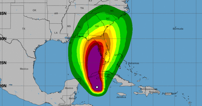
MIAMI, United States.- Hurricane Ian continues to rapidly intensify in the Caribbean as it moves closer to western Cuba, with winds now reaching 100 miles per hour (155 km/h).
According to him National Hurricane Center (NHC), at 5:00 p.m. this Monday, the eye of this system was found 155 miles (250 km) southwest of the westernmost tip of Cuba, at latitude 20.3 North, longitude 83.2 West, and is moving toward the north-northwest near 13 mph (20 km/h).
According to the report, Ian continues to intensify rapidly and has maximum sustained winds of 100 miles per hour (155 km / h), and a turn to the north with a slightly slower forward speed is expected for Tuesday.
The NHC report warned that conditions in the west of the island will deteriorate tonight, with significant winds and storm surge.
On the forecast track, the center of Ian is expected to move near or over western Cuba tonight and early Tuesday, then emerge over the southeastern Gulf of Mexico and pass west of the Gulf of Mexico by tomorrow night. Florida Keys.
There is currently a hurricane alert for the Cuban provinces of Isla de Juventud, Pinar del Río and Artemisa, and a tropical storm warning has come into effect for Grand Cayman.
That same notice has been issued for the Cuban provinces of Havana, Mayabeque and Matanzas; the lower Florida Keys, from the Seven Mile Bridge west to Key West and the Dry Tortugas.
A storm surge watch is active for the Florida Keys, Florida Bay, portions of southeast Florida, and Tampa Bay. Additionally, a hurricane watch is in effect from Englewood to the Anclote River, including Tampa Bay.
Rapid strengthening of Ian is expected over the next few days or so, and it is forecast to become a major hurricane tonight or early Tuesday when it is near western Cuba.
Ian is currently a category 2 hurricane on the Saffir-Simpson scale, out of a total of 5, but it is expected to reach force majeure when it reaches the Gulf of Mexico in the coming days.
Hurricane-force winds extend outward up to 35 miles (55 km) from the center, and tropical-storm-force winds extend outward up to 115 miles (185 km).
The estimated minimum central pressure is 972 mb (28.71 inches), and according to the NHC, the hurricane is expected to cause “significant impacts of winds and storm surges” in western Cuba.
Destructive winds are possible where Ian’s core moves across western Cuba and tropical storm conditions are expected within the Cuban tropical storm warning area tonight and Tuesday.
Likewise, “hurricane conditions are expected along the west coast of Florida within the hurricane warning area on Wednesday.”
Receive information from CubaNet on your cell phone through WhatsApp. Send us a message with the word “CUBA” on the phone +525545038831, You can also subscribe to our electronic newsletter by giving click here.


