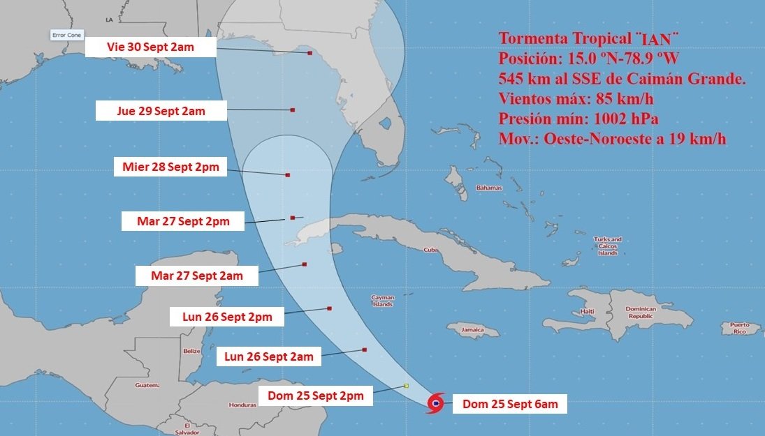
The tropical storm ian it gained in organization during the early hours of this Sunday, and although it still remains with little change in its intensity, forecasts indicate that it should become a hurricane this day and will continue to strengthen before hitting western Cuba next Tuesday.
In accordance with the notice of 6:00 this morning from the Cuban Institute of Meteorology (Insmet), at that time Ian had maximum sustained winds of 85 kilometers per hour (km/h), with higher gusts, and a central pressure of 1002 hectoPascal. In addition, his travel speed had decreased to 19 km/h.
These parameters were maintained two hours later, according to the part from the United States National Hurricane Center (NHC), except for the pressure that at 8:00 AM (local time) was 1001 hectoPascal. According to that information, at that time it was 950 km from the western tip of Cuba.
Here are the 5 am EDT Sunday Key Messages for Tropical Storm #Ian. Follow the latest at https://t.co/tW4KeGdBFb pic.twitter.com/PrHODJ0sMi
— National Hurricane Center (@NHC_Atlantic) September 25, 2022
For its part, the Insmet located it at 6:00 AM in the waters of the central Caribbean Sea about 545 kilometers south-southeast of Cayman Grande and 780 kilometers southeast of Cayo Largo del Sur, and noted that its movement has turned with heading near west-northwest.
“In the next 12 to 24 hours, the tropical storm will begin to tilt its trajectory to the northwest with a similar travel speed, rapidly gaining in organization and intensity, with the possibility of reaching the category of a hurricane this Sunday,” the Cuban entity points out.
“Given its position and the forecast trajectory, tropical storm Ian could cause strong winds, heavy and intense rains and coastal flooding in low-lying areas of the southern coast in this part of the Cuban territory (the western zone) starting on Monday, September 26” , add notice.
This is consistent with the NHC forecast, according to which “a turn to the northwest at a similar forward speed is expected later today, followed by a turn to the north-northwest on Monday and north on Tuesday,” time that “Ian is expected to become a hurricane later today or tonight and reach significant hurricane strength by late Monday or Monday night before it reaches western Cuba.”
So far, as decreed by the Civil Defense, are in the information phase the territories of the western region, from the province of Cienfuegos to Pinar del Río, including the special municipality of Isla de la Juventud. However, this phase must change as the storm approaches Cuban territory.
