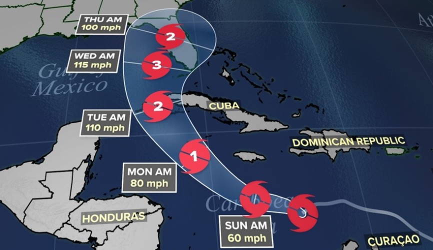
MIAMI, United States. — Tropical depression number nine of the current hurricane season became Tropical Storm Ian in the waters of the central Caribbean Sea on Saturday.
The US National Hurricane Center (NHC) reported that at eight o’clock today the center of the organism was located at 14.2 degrees longitude north and 74.5 degrees longitude west, about 485 kilometers south-southeast of Kingston, Jamaica, and about 915 kilometers southeast from Grand Cayman Island.
The NHC report indicates that the system has maximum sustained winds of up to 75 kilometers per hour (km/h), with higher gusts, and that it moves west at 24 km/h.
Due to the proximity and possible trajectory of Ian, the NHC issued tropical storm watches for the Cayman Islands and Jamaica, territories that could begin to suffer the ravages of the meteor in the next few hours.
“Strengthening is forecast during the next few days. It is expected to become a hurricane on Sunday night or Sunday night, “adds the report of the US entity.
The NHC noted that tropical storm-force winds from Ian extend from the center outward for a range of up to 75 km.
He also called on the authorities of Cuba and Florida to remain attentive to the evolution and possible trajectory of the cyclonic organism.
Forecasts warn that, starting tomorrow, Ian may begin to affect the western and central regions of Cuba with rains that can leave accumulations of between 6 and 10 inches, with a local maximum of up to 14.
According to the NHC, rainfall on the Caribbean island can produce flash flooding and mudslides in areas of higher ground.
In the Florida Keys and South Florida, heavy rain could start as soon as Monday.
Receive information from CubaNet on your cell phone through WhatsApp. Send us a message with the word “CUBA” on the phone +525545038831, You can also subscribe to our electronic newsletter by giving click here.


