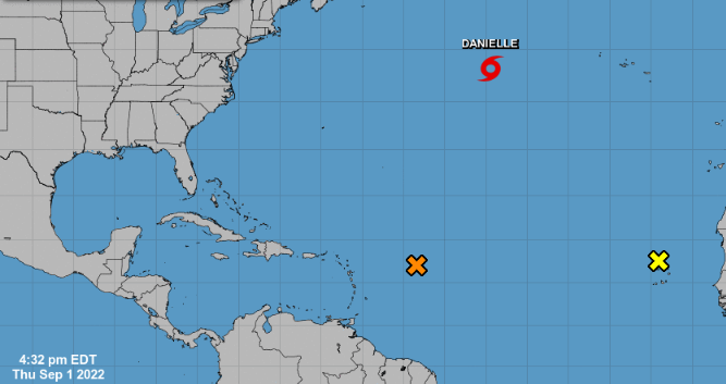
MIAMI, United States.- Tropical storm Danielle, the fourth of the current season, intensified this Thursday and will continue to gain intensity until it becomes the first hurricane in the Atlantic of 2022.
According to the National Hurricane Center (NHC), maximum sustained winds of Danielle increased to 60 mph (95 km/h) and was 950 miles west of the Azores Islands. While two other systems could become tropical depressions, the NHC forecasts that Storm Danielle will further strengthen and become a hurricane on Friday.
The National Hurricane Center estimates that Danielle does not pose a threat to Florida or other populated areas.
For their part, meteorologists have also reported that there are conditions for the formation of a tropical depression east of the Leeward Islands. “The showers and storms associated with a large area of low pressure located have changed and that although environmental conditions remain marginally conducive, any additional development during the next few days would lead to the formation of a tropical depression,” it reads. a note about it from NHC.
The disturbance is forecast to move slowly west-northwestward into the adjacent waters north of the Leeward Islands, with a 50% chance of formation over the next 48 hours and a 70% chance of formation over the next five days.
For its part, another tropical wave accompanied by a large area of low pressure that is located in the northwest of the Cape Verde Islands, although poorly organized, still has some possibility of becoming a short-lived tropical depression on Friday, before environmental conditions become unfavorable for further development. The National Hurricane Center explained that regardless of its development, the system could bring local heavy rains to parts of the Cape Verde Islands on Thursday. The probability of development is 20% at 48 hours and five days.
The current Atlantic hurricane season has been relatively quiet due to dry, dusty air from the Sahara Desert, combined with unfavorable wind shear, experts have said.
Last week, meteorologist Philip Klotzbach, known as the “Hurricane Guru”, said for the first time no named storms had been recorded in the Atlantic between July 3 and August 22 since 1982.
The National Office of Oceanic and Atmospheric Administration (NOAA) updated the forecast for the 2021 Hurricane season in the Atlantic in late August and between 14 and 20 named storms (winds of 39 mph or more) are now forecast, of which 6 to 10 could become hurricanes (winds of 74 mph or greater) and of those 3 to 5 could become major hurricanes (winds of 111 mph or greater).
Receive information from CubaNet on your cell phone through WhatsApp. Send us a message with the word “CUBA” on the phone +1 (786) 316-2072, You can also subscribe to our electronic newsletter by giving click here.


